


|
||

|

|
|

|
First Edition.
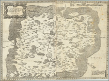
A rare carte-à-figures map of Bohemia and its surrounding regions by Johannes Janssonius, Bohemia In Suas Partes Geographice Distincta is a remarkable representation of seventeenth-century cartography and printmaking. Created in Amsterdam in 1620, this map draws upon the skills of three significant individuals of the period: cartographer and engraver Petrus Kaerius, draftsman Egidius Sadeler, and publisher Johannes Janssonius.
In the era of its creation, Bohemia represented a critical nexus of trade, culture, and political power in the heart of Europe. This map of Bohemia is adorned with six views of Bohemian towns (Praga, Egra, Zaslavia, Commona, Lavna, and Slana) and four pairs of depictions of individuals in Bohemian costume (Rex Bohemie, Regina Bohemie, Nobilis Bohemie, Nobilis Uxor Bohemie, Mercator Bohemie, Mercatoris Uxor Bohem., Rusticus Bohemie, Rustica Bohemie). These pictorial elements not only enliven the map but also provide a window into the region's cultural milieu and its significance in seventeenth-century Europe.
The complex combination of geographical delineation, urban views, and ethnographic vignettes in Bohemia In Suas Partes Geographice Distincta is representative of carte-à-figures, a popular style of map-making in the seventeenth century. This style, often found in Dutch cartography, aims to contextualize the geographical space by offering rich illustrations and marginal information, creating a comprehensive visual spectacle for the viewers.
The map is further distinguished by its meticulous detailing, including an exhaustive legend, "Notarum Explicatio," indicating the symbols for diverse features like royal and noble cities, villages, forts, monasteries, mineral deposits, spas, and glassworks. Moreover, a note regarding the names ending with a triangle reveals the map's focus on demarcating Bohemian lands.
A second edition was published a decade later, in 1630, making this 1620 edition a rare and treasured exemplar of Janssonius's early work.
Jan Janssonius (also known as Johann or Jan Jansson or Janszoon) (1588-1664) was a renowned geographer and publisher of the seventeenth century, when the Dutch dominated map publishing in Europe. Born in Arnhem, Jan was first exposed to the trade via his father, who was also a bookseller and publisher. In 1612, Jan married the daughter of Jodocus Hondius, who was also a prominent mapmaker and seller. Jonssonius’ first maps date from 1616.
In the 1630s, Janssonius worked with his brother-in-law, Henricus Hondius. Their most successful venture was to reissue the Mercator-Hondius atlas. Jodocus Hondius had acquired the plates to the Mercator atlas, first published in 1595, and added 36 additional maps. After Hondius died in 1612, Henricus took over publication; Janssonius joined the venture in 1633. Eventually, the atlas was renamed the Atlas Novus and then the Atlas Major, by which time it had expanded to eleven volumes. Janssonius is also well known for his volume of English county maps, published in 1646.
Janssonius died in Amsterdam in 1664. His son-in-law, Johannes van Waesbergen, took over his business. Eventually, many of Janssonius’ plates were sold to Gerard Valck and Pieter Schenk, who added their names and continued to reissue the maps.
![[ Bohemia / Czech Republic ] Bohemiae Nova Descriptio Tabula XVII](https://storage.googleapis.com/raremaps/img/small/95795.jpg)

![(Second World War - Prelude to War) Die Luftbedrohung Deutschlands [The Air Threat to Germany]](https://storage.googleapis.com/raremaps/img/small/84075.jpg)
![(Second World War - Sudetenland) Wer Braucht Sicherheit im Südosten? [Who Needs Security in the Southeast?]](https://storage.googleapis.com/raremaps/img/small/98159.jpg)