|
||

|

|
|

|
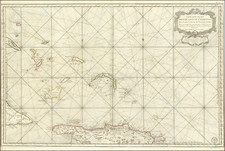
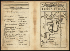
French Naval Sea Chart for The Eastern Caribbean Seas
Fine large sea chart covering the eastern Caribbean from the Virgin Islands to Aruba and Curacao, along with the contiguous coast of South America.
The mid-18th century was a tumultuous period for the Caribbean and its surrounding regions. As European powers scrambled to expand their territories and trade networks, the seas and islands of this region became the backdrop for power plays, military confrontations, and strategic maneuverings. It is within this historical context that this French Naval Sea Chart highlighting the Windward and Leeward Islands along with the contiguous coast of Venezuela and Suriname, assumes significance.
Drawing from the best available navigational knowledge, the chart depict the islands of the Caribbean in detail, ranging from the Virgin Islands in the north, down to the Dutch colonies of Aruba and Curacao to the south. The inclusion of rhumb lines – straight lines on maps that represent a constant compass direction were useful for aiding navigation, especially over long distances.
The 18th century Caribbean was a hotbed of commercial activity, and France, like other European powers, had significant economic stakes in the region. Sugar, tobacco, and indigo plantations dotted the islands. These plantations produced goods that were in high demand in Europe, promising lucrative returns for those who controlled their production and trade.
Moreover, the proximity of the Windward and Leeward Islands to the rich Spanish colonies in South America made them crucial points in illicit trade networks. French privateers often targeted Spanish galleons laden with silver and other treasures from the New World. The present chart would have been standard issue for French naval vessels operating in the region.
France's commercial ambitions in the Caribbean were matched by its military aspirations. Naval dominance in the region would ensure the protection of French trade routes and deter other European powers. The 7 Years War (1756-1763) was emblematic of this struggle for supremacy. The Caribbean saw several naval engagements, most notably the Battle of Les Saintes in 1782, where the British fleet led by Admiral George Rodney defeated the French under Comte de Grasse, thereby ensuring British naval dominance.
This mid-18th century French sea chart of the Windward and Leeward Islands, Venezuela, and Suriname, with its intricate details and rhumb lines, is not just a navigational tool. It is a testament to France's aspirations, commercial ambitions, and the broader geopolitical struggles of the period.
Jacques-Nicolas Bellin (1703-1772) was among the most important mapmakers of the eighteenth century. In 1721, at only the age of 18, he was appointed Hydrographer to the French Navy. In August 1741, he became the first Ingénieur de la Marine of the Dépôt des cartes et plans de la Marine (the French Hydrographic Office) and was named Official Hydrographer of the French King.
During his term as Official Hydrographer, the Dépôt was the one of the most active centers for the production of sea charts and maps in Europe. Their output included a folio-format sea atlas of France, the Neptune Francois. He also produced a number of sea atlases of the world, including the Atlas Maritime and the Hydrographie Francaise. These gained fame and distinction all over Europe and were republished throughout the eighteenth and even in the nineteenth century.
Bellin also produced smaller format maps such as the 1764 Petit Atlas Maritime, containing 580 finely-detailed charts. He also contributed a number of maps for the 15-volume Histoire Generale des Voyages of Antoine François Prévost.
Bellin set a very high standard of workmanship and accuracy, cementing France's leading role in European cartography and geography during this period. Many of his maps were copied by other mapmakers across the continent.
The Dépôt de la Marine, known more formally as the Dépôt des cartes et plans de la Marine, was the central charting institution of France. The centralization of hydrography in France began in earnest when Jean-Baptiste Colbert became First Minister of France in 1661. Under his watch, the first Royal School of Hydrography began operating, as did the first survey of France’s coasts (1670-1689). In 1680, Colbert consolidated various collections of charts and memoirs into a single assemblage, forming the core of sources for what would become the Dépôt.
The Dépôt itself began as the central deposit of charts for the French Navy. In 1720, the Navy consolidated its collection with those government materials covering the colonies, creating a single large repository of navigation. By 1737, the Dépôt was creating its own original charts and, from 1750, they participated in scientific expeditions to determine the accurate calculation of longitude.
In 1773, the Dépôt received a monopoly over the composition, production, and distribution of navigational materials, solidifying their place as the main producer of geographic knowledge in France. Dépôt-approved charts were distributed to official warehouses in port cities and sold by authorized merchants. The charts were of the highest quality, as many of France’s premier mapmakers worked at the Dépôt in the eighteenth century, including Philippe Bauche, Jacques-Nicolas Bellin, Rigobert Bonne, Jean Nicolas Buache, and Charles-François Beautemps-Beaupré.
The Dépôt continued to operate until 1886, when it became the Naval Hydrographic Service. In 1971, it changed names again, this time to the Naval and Oceanographic Service (SHOM). Although its name has changed, its purpose is largely the same, to provide high quality cartographic and scientific information to the France’s Navy and merchant marine.
![Venezuela cum parte Australi Novae Andalusiae [First State!]](https://storage.googleapis.com/raremaps/img/small/100104.jpg)