- Antique Maps
- United States
- Mid-Atlantic
- A New Map of Virginia with its Canals, Roads &...
Map Maker
Title
A New Map of Virginia with its Canals, Roads & Distances from place to place , along the Stage and Steam Boat Routes . . .
Publication Place / Date
Philadelpha / 1854
Image Dimensions
14.5 x 11.5 inches
Color
Hand Colored
Condition
VG+
Stock# 79981
$ 245.00
Map Maker
Authenticity Guarantee
All of our maps are authentic antique maps, printed or drawn on or about the date shown in the description. In rare instances when we offer facsimiles, we will specifically describe the map as a later facsimile and include the date of publication. Certificates of Authenticity are included with each item.
Map Maker
Fast, Global Shipping
Last year we shipped over 4,500 antique maps to more than 50 countries. Maps are shipped Monday through Friday year-round. If an order is received before 2 PM PST, we will ship the order that day. If an order is received after that time, we will ship the next day. We ship maps either flat in custom packages or in specially ordered thick tubes. Shipping rates are provided as part of the checkout process.
Description
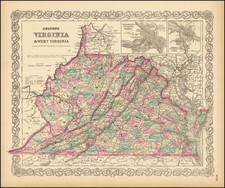
Nice example of Cowperthwait's early map of the State of Virgina, showing counties, towns, rivers, roads, mountains, lakes, canals, etc.
Profile of the Chesapeake and Ohio Canal at the top of the map and a schedule of steamboat routes and distances at the bottom.
Related Categories
Related Items