


|
||

|

|
|

|
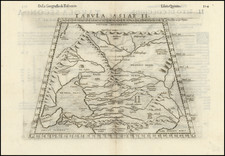
Finely colored example of Waldseemuller's map of India, one of the earliest obtainable maps of the region. This woodblock was printed in Strasbourg, an important early center of secular printing. The first map appeared in Martin Waldseemuller's Geographiae opus novissima traductione e Grecorum archetypis castigatissime pressum.
The depiction of India is stunted, and shows the subcontinent from the Indus in the west to the Ganges in the East. In the south, an oversized Taprobana (Sri Lanka), is half-shown. Large mountains in the north source the many Indian rivers, reflecting the Himalayas. Ancient towns and regions are named.
Waldseemuller's Geographiae is often referred to at the first modern atlas, incorporating twenty new modern maps. The twenty-seven maps of ancient geography that constitute the first part of the work are copied from the 1482 Ulm edition of the Ptolemy, one of the finest editions of the work and the first printed outside Italy. The supplement of twenty maps represents the first complete series of "modern" maps, produced by Martin Waldseemüller at Saint-Dié. The new Latin translation of the text that accompanies the maps was produced by Mathias Ringmann is based on D'Angelo's text and edited by Jacob Aeschler and Georg Uebelin.
This geography includes many important maps, including the first map exclusively devoted to America ("Tabula terre nove"); Lorraine, one of the earliest color printed maps; as well as the first published maps for many other countries. Waldseemüller's maps made considerable geographical advances, basing their information on material in the Basel and Strasbourg university libraries, as well as reports of Spanish and Portuguese voyages. No better assemblage of maps was issued until Ortelius's Theatrum Orbis Terrarum of 1570.
Original Hand-Coloring
It is very rare to encounter Waldseemuller's 1513 maps in original hand-color; this being one of the few times we have offered any of the maps for sale. See Chet van Duzer's work on the subject for an in-depth discussion of the coloring of the 1513 Waldseemuller.
Martin Waldseemüller (c. 1475-1520) was a sixteenth-century cosmographer best known for his 1507 world map in twelve sheets, the earliest surviving map to include the name “America.” He was an influential mapmaker during his time whose work affected many of his contemporaries and successors. Waldseemüller was born near Freiburg, in what is now southwestern Germany. His family moved to Freiburg proper when he was young and he attended university in the city beginning in 1490.
Waldseemüller gathered information about the New World discoveries and geography from St.-Dié des Vosges in Lorraine, where he was a professor of cosmography under the patronage of René II, Duke of Lorraine. He was a member of an intellectual circle who produced work from the St.-Dié Press. However, the press failed when the Duke died, and Waldseemüller moved to Strasbourg.
He is best known for the 1507 map and another world projection, the Carta Marina published in 1516. He also published an edition of Ptolemy in 1513, in collaboration with Johann Schott, a friend from Freiburg and St.-Dié. Besides his innovative use of the toponym “America”, Waldseemüller was the first to create such a large printed world map, the author of the earliest known printed globe gores, the first to create a published collection of modern maps, and one of the first to create maps from ground measurements. He was knowledgeable in surveying methods and designed a quadrant and other instruments. He returned to St.-Dié late in life as canon, although he continued to return to Strasbourg for work and for carnival. He died in St.-Dié in 1520.
Waldseemuller is generally credited with having named the continent of America, based upon the then current belief that Amerigo Vespucci had been the first modern explorer to reach the continent of America in 1497, during the first of four expeditions to America which were then credited to Vespucci between 1497 and 1504. The report which described the 1497 expedition is now generally believed to be a forgery. Later in his career, Waldseemüller elected not to use the toponym for the continents, preferring to leave them unnamed. However, the name had been taken up by his contemporaries, in large part due to the influential nature of Waldseemüller’s earlier works.
![Tabula IX Asiae [Pakistan & India] (Title on Verso)](https://storage.googleapis.com/raremaps/img/small/49098.jpg)
![Calcutta & Howrah Guide Map [with] Calcutta & Howrah Guide Map (1st Edition 1933) Alphabetical Index to Names. Tape Indicator Issue.](https://storage.googleapis.com/raremaps/img/small/101270.jpg)
![Tabula Asiae IX [Northern India & Pakistan]](https://storage.googleapis.com/raremaps/img/small/77557.jpg)