|
||

|

|
|

|
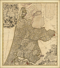
Decorative and highly detailed map of the Netherlands, published in London by Emanuel Bowen in the mid-18th century for his A Complete System of Geography.
The map shows Holland, then known as the United Provinces, divided into regions. Cities, canals, sandbars, and more are all shown. Belgium, to the south, is divided into Flanders and the Austrian Netherlands. A separate map, included at the bottom, is entitled: A Chart of Part of the Sea Coast of England, Holland, Zeeland and Flanders
This map is a fantastic chart of the north sea, stretching from Essex and Kent eastwards to Flanders. Across the sea, soundings, sea roads, and sandbars are all shown.
The map further includes a decorative cartouche showing Dutch farmers. This map was produced to show the extent of the United Provinces, also known as the Dutch Republic, the precursor nation to the Netherlands which managed to preserve its independence from the Dutch Revolt in 1588 to the Batavian Revolution in 1795.
Emanuel Bowen (1694?-1767) was a British engraver and print seller. He was most well-known for his atlases and county maps. Although he died in poverty, he was widely acknowledged for his expertise and was appointed as mapmaker to both George II of England and Louis XV of France. His business was carried on by his son, Thomas Bowen. He also trained many apprentices, two of whom became prominent mapmakers, Thomas Kitchin and Thomas Jeffreys.
![[Course of the Rhine River] Corso del Reno Parte Septentrio [and] Corso del Reno Parte Meridionale . . . 1690](https://storage.googleapis.com/raremaps/img/small/73095.jpg)