|
||

|

|
|

|
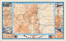
The Defining Geological Map of the Central Rockies of the 19th Century.
Spectacular geological map of central Colorado, colored based upon the mineralogical content of the region, from the second edition of Hayden's Colorado Atlas. This is one of the earliest maps we have been able to locate to show the town of Aspen, which was first labeled on maps starting in 1880.
This fantastic map stretches from Colorado Springs in the west through the high Rockies. This map originally appeared in Ferdinand Vandeveer Hayden's Geological and Geographical Atlas of Colorado, possibly the most important and extensive early survey of the state.
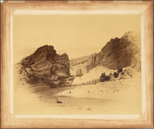
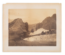
The map is centered headwaters of the South Platte River, showing Pueblo, Greenhorn Station, and Colorado Springs in the east, with Aspen, Roaring Fork, Crested Butte, and Gunnison in the far west of the map. Leadville and Mt. Ebert are shown in the north. Hayden was an important early mapper in this region, and one of the first to scientifically and mechanically inspect the region. In one of his reports, regarding Castle Creek which flows from Star Peak to the Roaring Fork River near Aspen, Hayden states that:
"The gorges or canyons cut by Castle and Maroon Creeks and their branches are probably without a parallel for ruggedness, depth, and picturesque beauty in any portion of the west. The great variety of colors of the rocks, the remarkable and unique forms of the peaks, and the extreme ruggedness, all conspire to impress the beholder with wonder."
The map shows thirty-one types of strata, which give the map a depth of image that adds to the object's attractiveness. Strata range in age from quaternary to Silurian, although some granites are purported to be Archean by Hayden. Silver- and gold-bearing deposits are shown. This region reflects the confusing geology of the Rocky Mountains as a whole, where vastly different terranes (strata with differing geological histories) collide and form complex patterns. In this part of Colorado, the land was initially formed as island volcanic arcs (comparable to modern-day Japan or Indonesia) which were then shoved together during the recent Laramide Orogeny.
Hayden's Colorado Atlas maps are issued on unusually thick paper for government-issued 19th geographical surveys and are significantly less susceptible to wear than some comparable survey maps.
The Hayden Survey of Colorado
The late 1860s and early 1870s saw four great surveys of the American West: the King Survey, which mapped the region around the 40th parallel; the Wheeler Survey, which attempted (unsuccessfully) to map the whole of the territories and western states at a moderate scale; the Powell Survey, which focused on the southwest and the Grand Canyon region; and finally the Hayden survey, which surveyed the territory of Colorado as well as the last great unmapped region of the Lower Forty-Eight: the Yellowstone Basin.
The Colorado survey was sandwiched between Yellowstone surveys and conducted in the years 1873-75. Hayden expected Colorado to soon become an important region because of the arrival of the railroads, and thus decided to expend enormous resources in order to create what would be one of the most extensive regional surveys anywhere in the world.
Each year, Hayden would subdivide his team into four groups, each consisting of a number of geologists, cartographic experts, and scientists, with each group assigned to a specific area. Hayden would always reserve the most interesting of the regions for himself: that is how he came to personally map the area around Aspen. The details of this survey are immensely interesting. Please refer to Thomas P. Huber's work, linked to in our references, for more information on the survey.
Aspen, Colorado
Hayden's map is one of the earliest maps to name Aspen, which can be found in the upper left of the map. Aspen's founding is well-known to have been born of the Colorado silver boom following the 1879 discovery of silver in nearby Leadville. Its first appearance on a map is under the name of Ute City. Shortly after, it was renamed to Aspen in 1880. Two 1880 maps name Aspen, making this likely to be the third map to show the town.
Thomas P. Huber has a fantastic description of the Hayden survey at the following link: https://haydenslandscapes.com/intro.
Ferdinand Vandeveer Hayden, known to the Sioux as "man-who-picks-up-stones-running," stands among the pantheon of eminent geologists of the 19th century.
Hayden's academic career commenced at Oberlin College, and he furthered his education at Albany Medical College, where he received his M.D. in 1853. Despite his medical training, Hayden was primarily engaged in geology, a field to which he would dedicate his life's work.
Hayden commenced his geological career with a survey in the Nebraska Territory in 1856. In 1859 and 1860, he conducted further exploratory work in the Rocky Mountains, particularly in Colorado, which was then part of the Nebraska and Kansas territories. His early work in the field earned him the respect of Native American tribes, with the Sioux reportedly dubbing him "man-who-picks-up-stones-running" due to his avid and energetic collection of geological samples during his expeditions.
By the 1860s, Hayden had risen to prominence as a geologist and was appointed the United States Geologist for the Geological Survey of the Territories. This role would define his career, leading numerous surveys in the Western United States. Notably, from 1871 to 1872, Hayden led a survey into the region that would become Yellowstone National Park, and his reports significantly contributed to the establishment of Yellowstone as the first National Park in 1872.
Hayden's most significant contribution to geological literature was the Geological Atlas of Colorado, published in 1877. This work was the result of comprehensive surveys conducted across Colorado, meticulously documenting the state's geography and geology. The atlas offered detailed maps on a scale previously unseen, encompassing not only Colorado but adjacent areas, including parts of Utah, Arizona, and New Mexico.
Hayden's influence extended to academia, as he was affiliated with the University of Pennsylvania for a period, where he held the position of professor of geology. His academic and field work combined to form a substantial body of knowledge that would be used by future scholars and explorers.
Ferdinand V. Hayden passed away on December 22, 1887, in Philadelphia, Pennsylvania. His enduring legacy is reflected in the numerous natural features named after him, including Hayden Valley in Yellowstone and Mount Hayden in Colorado. His contributions to geology during the 19th century remain a cornerstone of American geological and geographical sciences.

![[Aspen] Snowmass Village](https://storage.googleapis.com/raremaps/img/small/63539.jpg)