|
||

|

|
|

|
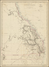
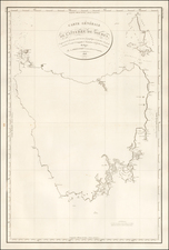
Exploring South Australia—Governor George Grey’s 1844 Expedition
Detailed map of South Australia showing the coastline from Encounter Bay to Discovery Bay, near Adelaide.
The map was made by the firm of John Murray for publication in the Journal of the Royal Geographical Society, the world’s premier publication for exploration in this period. It shows the route taken by Governor George Grey on his expedition along the coast of South Australia.
The main map shows Grey’s progress in April and May of 1844. The track marks his route, while notes give the date he was there, points out watering spots, and describes geographic features. At its furthest southern extent, Grey ventured into a maintain range. Two of these mountains, Mt. Schanck and Mt. Gambier, are shown in insets to the right.
At left are two views drawn near Mt. Schanck. One shows the mountain itself, while the other shows Devil’s Punch Bowl. A note on the map explains that this aqueous feature is 132 feet deep with freshwater. Both views were drawn by George French Angas, who accompanied Grey on the mission.
It is likely that this map was drawn from a manuscript map made by expedition member, and the Deputy Surveyor General, Thomas Burr. In a report to Lord Stanley, Colonial Secretary, of June 22, 1844, Grey mentions that he is sending:
an accompanying map of the newly-explored country, executed by Mr Deputy Surveyor-General Burrs contains plans and elevations of two volcanic mountains, which convey a very good idea of the character of these hills; and the enclosed sketch by Mr F. Angas, a young artist who accompanied me, represents very faithfully one of the most remarkable of another species of craters, which are very numerous in this country and which are filled with fresh water, and are almost unfathomable.
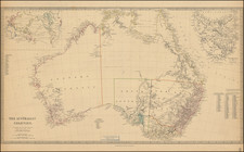
Exploration of Southern Australia to 1820
Indigenous peoples have lived in Australia for 40,000 years. As was common with maps and charts of the nineteenth (and earlier) centuries, their presence is not recognized here.
The first Europeans to contact southern Australia were the Dutch. En route to the East Indies, many Dutch traders decided to brave the fierce winds of the Roarin’ Forties (latitude) to speed their journey. However, this gamble sometimes resulted in being blown too far, onto an unknown (to Europeans) shore. While these first encounters, with the west coast, were largely accidental, later voyages sought to see what the continent had to offer.
The first European associated with southern Australia was Pieter Nuyts. Nuyts was an employee of the Dutch East India Company (VOC). In the Gulden Seepaert (Golden Seahorse), and captained by Francois Thijssen, Nuyts sailed nearly 800 nautical miles along the southern coast in 1627, reaching present-day Ceduna. As the highest-ranking officer on board, the land was named for him, Land van Pieter Nuyts.
By the end of the seventeenth century, the VOC had largely abandoned the idea of a colony or outpost in Australia. By the turn of the eighteenth century, in contrast, all of Australia was hotly contested by both France and Britain; the latter had already established their penal colony in eastern Australia. In 1801, the French ships Géographe and Naturaliste, under the command of Nicolas Baudin and Emmanuel Hamelin, surveyed much of the coastline.
Louis-Claude de Freycinet was the main hydrographer on the Baudin voyage who oversaw the publication of its account and atlas. Freycinet and the Baudin expedition were charting Western Australia at the same time a British expedition, under the command of Matthew Flinders, was doing the same; Flinders’ would eventually complete the first circumnavigation of Australia. He was detained by the French, however, and delayed in publishing his findings. Louis de Freycinet returned in command of his own expedition in 1818.
The early exploration and settlement of South Australia
Inland exploration of South Australia began in earnest only two decades prior to this map’s production. In 1819, a sealing captain named George Sutherland crossed Kangaroo Island on foot. Ten years later, from 1828-30, Charles Sturt traveled upriver on several voyages, locating the Darling and following the River Murray to its mouth. The surrounding area was fertile and led many to see South Australia as a viable new colony.
South Australia was officially proclaimed a colony in 1836, with the new planned settlement of Adelaide as its capital. Its location was decided thanks to a route from the Murray to Gulf St. Vincent, which was blazed by Collet Barker in 1831. From 1836 to 1844, other explorers sought more information about the inland areas, including Johann Menge, who conducted geological investigations, and Robert Cock, who led several trips to find resources.
These trips found that, only a little way into the interior, the climate turned arid and the land dry. Joseph Hawdon and Charles Bonney traced the Murray corridor in 1838; Bonney continued on the Coorong the following year. Combined with Grey’s 1844 expedition, which included Bonney, these sorties delimited the fertile “island” of South Australia.
The expeditions of George Grey
This map focuses on one expedition of Sir George Grey. George Grey was a soldier who had led two expeditions in Western Australia from 1837 to 1839. Grey was given command at only 25 years of age, ordered to investigate if an Australian river emptied into the Indian Ocean at any point along the coast. The expedition was supported by the Royal Geographical Society.
Woefully inexperienced and unprepared, Grey and his men began their first foray near Hanover Bay, northwestern Australia. They experienced floods and extreme thirst, Grey was stabbed by a spear, and they had to be rescued by the Beagle, upon which Grey had sailed to Cape Town from England.
He then traveled to Perth in late 1838. By February 1839, Grey was ready for another excursion. This time he and his men sailed to Shark Bay. They were supposed to explore to the northwest, but were met with fierce weather. They crossed to the mainland, making it to the Gascoyne River. They decided to turn south, for Perth, in a small boat. The boat was wrecked at Gantheaume Bay, forcing the explorers on a 300-mile overland journey. They survived thanks to the help of Kaiber, a Whadjuk Noongar man.
Despite these two disastrous journeys, Grey was promoted captain and appointed as resident magistrate of King George Sound. He published Vocabulary of the Dialects spoken by the Aboriginal Races of South-Western Australia, which was later reprinted in London (1840). Grey then returned to England to promote settlement in Western Australia. He completed Journal of Two Expeditions of Discovery, with maps by John Arrowsmith, while in Brighton.
The 1844 expedition
Grey was then named Governor of Southern Australia, ending his army career. After a rocky start, and at the expense of his predecessor, Grey enacted austerity measures and had nearly balanced the colony’s books by 1844.
His expedition of that year, illustrated here, was in large part to establish better relations with the local Aboriginal people, who unsurprisingly resisted the settlement and expansion of the colonists. It was not a trailblazing venture, as by that time that area was relatively known, at least to locals. Nevertheless, Grey’s group named several features, including Lake George, Lake Eliza, Lake Frome, Lake Bonney, and Mount Burr.
Soon after this expedition, Grey left to serve as the Governor of New Zealand from 1845 to 1853, and again from 1861 to 1868. In the interim, he was Governor of the Cape Colony. From 1875 to 1895, he served in the Parliament of New Zealand, becoming Prime Minister from 1877 to 1879. In 1894, Grey returned to England, dying in London in 1898.
The most significant outcomes of the 1844 expedition were this map and Angas’ drawings and paintings. It is a fascinating artifact from an early period in South Australia’s history, from an expedition led by one of the most important early figures in Australian and New Zealand history.