|
||

|

|
|

|
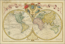
Fine example of this allegorical and highly double-hemisphere decorative map of the world. The map is important for its showing of the recent travels of important explorers and bases its geography on the earlier Jaillot/de La Tour map of 1782.
The map is uniquely remarkable for its extremely ornate allegorical depictions of the continents that grace the corners of the map. Five female figures are shown, representing the continents. The largest of all of them, and the one that the other four look to, is, of course, the one meant to represent Europe, who is riding a Roman chariot. The other figures sit near depictions of the fauna, flora, and decorations meant to embody the continents.
The highly ornate cartouche includes advertisements for a number of other maps published by the same firm. The map is dated to the "Year VII," reflecting the period of the French Revolution.
The geography shown on the map is striking. To the south, no continent is shown. However, the zig-zag track of Cook’s ship shows just how far south he went and puts to rest the myth of a gigantic southern continent forever. Although no continent rests at the pole, there are islands of ice mentioned across both hemispheres. Included too are the southern islands Cooks sighted on his second voyage, such as Terre de Sandwich, which at the time was the most southerly landfall known.
North America is recognizable, but the shape and extent of California was still clearly a matter up for debate. The shape of Alaska too is familiar yet not the precise delineation we know today. Cook’s far northerly trek is noted, a part of his third expedition.
This is the first time we have offered the presented map for sale.
The voyages of Captain Cook and his men
The map is a chronicle of Cook’s three voyages, which put many features on European maps for the first time and drastically rewrote how Europeans understood Pacific space and peoples. Cook originally worked in coal colliers, and then as a surveyor in Newfoundland. There, his superb navigational and surveying skills were noticed, and he was recommended to lead a new Royal Navy voyage then preparing to sail. This voyage was meant for the South Seas, from where the crew would observe the Transit of Venus as part of a transnational scientific team.
The Transit of Venus would be the first of Cook’s three Pacific voyages. Cook sailed in the Endeavour on August 25, 1768, bound for Tahiti, which is written here as Otahiti. They sailed round Tierra del Fuego, on to Tahiti, and then to New Zealand. Cook’s map of New Zealand, the basis for the outline used here, would stay in use until the early twentieth century. From New Zealand, the Endeavour sailed to and then up the eastern coast of Australia. It nearly wrecked on the Great Barrier Reef, but thanks to hasty repairs managed to sail to Batavia, then to the Cape of Good Hope and back to England in July 1771.
Cook’s second voyage was centered around a different goal: the search for the elusive southern continent. This time, Cook, in the Resolution, was to be accompanied by another ship, the Adventure, under the command of Tobias Furneaux, whose track is also on this map. The ships sailed from Plymouth in July of 1772. They rounded the Cape of Good Hope and went south. The ships crossed the Antarctic Circle on January 17, 1773, the first ships known to have done so. The ships were then separated but rendezvoused in New Zealand. Furneaux, as shown by his track, went south and touched Tasmania; however, he thought the island was attached to the mainland.
The ships then returned to Tahiti, where the Adventure picked up Mai, who would become the first Polynesian to visit Britain. The ships went again to New Zealand but were separated; Cook continued south while Furneaux decided to return home. The Resolution proceeded to search for the southern continent, eventually reaching as far south as 71˚10’ S, the farthest south of any ship until 1823. Then the Resolution put in at Easter Island before returning again to Tahiti. The ship sailed to the New Hebrides (Vanuatu), New Caledonia, and New Zealand before rounding Cape Horn to head home. En route, Cook claimed South Georgia as related above. The ship stopped at the Cape of Good Hope before returning to Britain in late July 1775. Furneaux had arrived over a year before.
Cook’s third and final voyage was supposedly to return Mai to his home, yet it was secretly intended to search for the Northwest Passage. Cook sailed this time, again in the Resolution, with the Discovery, which was under the command of Charles Clerke. The ships spent Christmas of 1776 in the Kerguelen group, then went on to Tasmania and New Zealand and Tahiti. This portion of the voyage is not shown on this map. The track shown here begins in late 1777, when the ships turned north, eventually reaching Kauai, then called the Sandwich Islands by Cook, in January 1778.
From Hawaii, the ships sailed farther north still, reaching what is today the Northwest of the United States and Canada and coasting north to what is now Alaska. They crossed the Arctic Circle in August 1778. As in the southern polar region, the ships were turned back by ice. The ships returned to Hawaii to take on provisions. They were welcomed by the people at Kealakekua Bay. The ships left but were forced to return when the Resolution’s mast broke. This time, the people of Kealakekua got into a dispute with Cook; he was killed on February 14, 1779, along with four marines and at least 16 Hawaiians.
After Cook’s death, Charles Clerke assumed command of the expedition. He returned the ships north, but ice again deterred them. Clerke died in August, leaving John Gore in charge. The ships went to Kamchatka and then near Japan before anchoring at Macao. At Macao, they sold sea otter pelts and started the fur trade that would decimate several species of the North Pacific. From there, the two ships rounded the Cape of Good Hope and returned to the Thames in early October 1780. The three voyages had changed geography, and certainly this map, forever.
![[ Ancient World ] Aevi Veteris, Typus Geographicus](https://storage.googleapis.com/raremaps/img/small/85526.jpg)