|
||

|

|
|

|
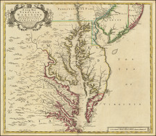
Very Rare Early Swedish-Published Map of the Delaware River
Fascinating map of Delaware, New Jersey, and Pennsylvania showing the course of the Delaware River. This map was first published by Thomas Campanius in a translation of Martin Luther's Catechism that the King of Sweden wanted to send to descendants of the settlers of New Sweden, and is based on a manuscript adaptation of a larger non-surviving map, both of which were by Pehr Lindhestrom (Lindstrom).
The map is remarkable in that it shows settlers' names as well as very early place names on the banks of the Delaware. Inland, decorative elements include wildlife, a compass rose, Native Americans, and a massive bonfire. Ships and fish can be found in the waters, and the coat of arms of the Swedish realm appears. The mouth of the Schuylkill River can be identified and is named Skiar eller linde Kil.
The map is based on a series of manuscripts prepared by Pehr Lindhestrom, who was in the colonies as early as 1654. Later, in 1696, Karl XI had a large example of the present map engraved, of which no examples are known to survive. This was fortunate, as the Stockholm palace fire of 1697 destroyed the original manuscripts. Karl XI also had a smaller version engraved, which was the first state of the present edition. This was included in the literature that was sent to the colonists, even though the colony of New Sweden had long since disappeared.
New Sweden only existed from 1638 to 1655, and was the only remotely successful colony to be founded by the Swedish South Company. Their first settlement was Fort Christina, built at the present-day location of Wilmington, Delaware. The colony grew over time, establishing Fort Elfsborg ["Elsembourg"] and Fort Gothenburg, both visible on this map. The nearby Dutch colonies felt threatened by the rapid growth of New Sweden, and the Second Northern War served as a pretext for them to take over these lands.
This map was published long after the demise of the map is often misattributed to Thomas Holm, which is a misreading of the imprint at the bottom that actually refers to Holmensis, the traditional name for Stockholm.
States
The map appears in two states, of which this is the second. Thomas Campanius first used the map in his translation of the Catechism, and then reissued the map as part of his Kort Beskrifning om Provincien nya Swerige uti America.
- 1696. Title given as Nova Suecia
- 1702. Pagination added and title updated to Nova Suecia hodie dicta Pensylvania
Rarity
This map is almost never encountered on the market as a separate.
Burden 721
![(Three Days at Gettysburg) Map of the Battlefield of Gettysburg July 1st, 2nd, 3rd 1863. . . [Three Maps]](https://storage.googleapis.com/raremaps/img/small/101769.jpg)
![[Delaware Indian Fort in New Sweden]](https://storage.googleapis.com/raremaps/img/small/79461.jpg)