|
||

|

|
|

|
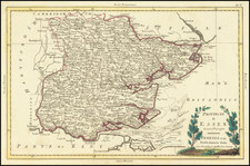
Attractive original antique map of the southernmost of the historical counties of Wales, Glamorgan. Containing a great many decorative elements, the map is a prime example of 17th-century Dutch School cartography.
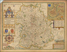
The map shows Glamorgan a century after it had fallen under English rule. The map contains numerous features, including cities, mountains, towns, and more. The cartography is derived from the John Speed map of the same county first published in 1610.
Numerous decorative elements are on display throughout the image, including sailing ships, the coat of arms of the royal family, and three additional cartouches. The map originally appeared in Bleau's atlas of the British Isles, first published in 1645 as part of his Atlas Novus.
Willem Janszoon Blaeu (1571-1638) was a prominent Dutch geographer and publisher. Born the son of a herring merchant, Blaeu chose not fish but mathematics and astronomy for his focus. He studied with the famous Danish astronomer Tycho Brahe, with whom he honed his instrument and globe making skills. Blaeu set up shop in Amsterdam, where he sold instruments and globes, published maps, and edited the works of intellectuals like Descartes and Hugo Grotius. In 1635, he released his atlas, Theatrum Orbis Terrarum, sive, Atlas novus.
Willem died in 1638. He had two sons, Cornelis (1610-1648) and Joan (1596-1673). Joan trained as a lawyer, but joined his father’s business rather than practice. After his father’s death, the brothers took over their father’s shop and Joan took on his work as hydrographer to the Dutch East India Company. Later in life, Joan would modify and greatly expand his father’s Atlas novus, eventually releasing his masterpiece, the Atlas maior, between 1662 and 1672.