


|
||

|

|
|

|
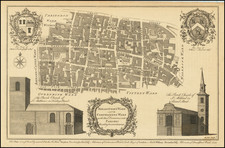
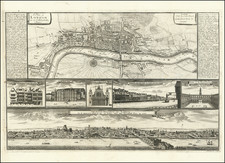
Attractive original antique map showing the heart of the City of London, showing the region around the Walkie Talkie. The map shows the area bounded by Fenchurch Street, Lombard Street, and Canon Street, and centered on Gracechurch Street (now the A10).
Detail is extensive, with the outlines of buildings drawn and many streets, lanes, and alleys all depicted. Churches are shown pictorially, and a view of four local parish churches, including St. Mary Woolnoth. The map is dedicated to the aldermen of the two wards depicted: Sir Joseph Hankey and Sir Charles Asgill. Their coats of arms are shown in the lower left of the map.
The map was engraved for Maitland's Survey of London, which showed London in the middle of the 18th century and for which Cole engraved numerous maps.
![[ London ] Bourse de Londres](https://storage.googleapis.com/raremaps/img/small/102982.jpg)