|
||

|

|
|

|
Stock# 79215
Description
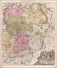
Original antique map showing five important farming areas north of Amsterdam. This map was published by Valk and Schenk in Amsterdam around the year 1700.
These maps appear to show five "polders" or areas of reclaimed land. Beemster, shown, is the first of these such polders in Amsterdam, which required high levels of technical engineering of drainage systems and flood protection in order to be habitable. Beemster Lake was dried up between 1609 and 1612 using windmills.
One of these reclaimed lands is just north of Amsterdam, near the present-day Noord District.
Condition Description
Original hand-color in outline.
![[ Lower Rhine River & Wesser River Region ] Die dritte Tafel des Rheinstroms / Innhaltend das Nider Teutschlandt](https://storage.googleapis.com/raremaps/img/small/81288.jpg)
![[ Holy Roman Empire ] A Newe Mape of Germany Newly Augmented by Iohn Speed Ano Dom: 1626](https://storage.googleapis.com/raremaps/img/small/68482.jpg)