|
||

|

|
|

|
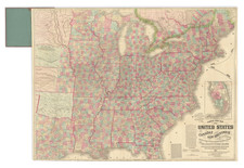
Fantastic set of five maps showing the distribution of agricultural products throughout the United States in the era following the Civil War. This map appeared in several of Alfred Theodore Andreas's atlases, including his Illustrated Historical Atlas of the State of Iowa.
The map shows were wheat, hay, corn, cotton, and tobacco are cultivated, with a key showing four to five grades of density. A note says that these gradings are relative, and census data does not show exact quantities.
The statehood map represents that of the modern-day, with the exception of Oklahoma being named Indian Territory and North and South Dakota being joined.
Alfred T. Andreas (1839-1900) was a tour de force when it came to commercial cartography and promotion. He built a sales machine that had agents crisscrossing the states he intended to map, selling subscriptions in return for portraits being placed in the back of his atlases. Andreas was especially active in the Upper Midwest; he was responsible for state atlases of Minnesota (1874), Illinois (1876), Wisconsin (1878), and Iowa (1875).
Ristow says of Andreas' plans for future state atlases:
ANDREAS anticipated that the Minnesota volume would be the first in a series of illustrated state historical atlases. As soon as his surveyors and canvassers had completed their work in Minnesota, they were accordingly shifted to Iowa to begin work on an atlas there. Procedures for preparing the Iowa atlas and for soliciting subscriptions and contracts for illustrations and biographical sketches were the same as for the Minnesota volume.