|
||

|

|
|

|
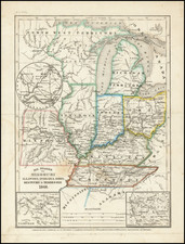
Early geological map of the Isle Royale, published in New York for the 31st Congress. This is almost certainly the earliest geological map of the island to delineate its geology correctly.
On the map, three Silurian units are denoted, a sandstone, a conglomerate, and a basic igneous unit. In addition, early mines are denoted. The map accurately shows the southeast dipping strata which define the island. The system is part of a syncline generated by two faults, the second of which underlies the Keweenaw Peninsula.
The survey and map are by geologists J.W. Foster and J.D. Whitney with assistance from S.W. Hill and W.S. Chlatter. It originally appeared in their Report on the Geology and Topography of a portion of the Lake Superior Land District in The State of Michigan.
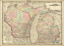
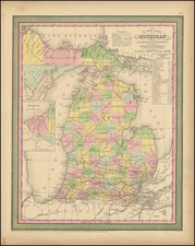
Foster and Whitney Mapping the Great Lakes
This map was included in a report was presented to the House of Representatives, following an 1847 commission to survey the land with a particular focus on copper mining. This survey was completed by J. W. Foster and J. D. Whitney.
Copper deposits in the Lake Superior region had been known to the Native Americans (copper mining deposits six thousand years old have been discovered) and appeared on the first geological map of North America, published in 1756. After treaties with the Indians in the 1830s and 1840s, public interest grew in exploiting these deposits. The state of Michigan attempted a survey, but the efforts were abandoned when the lead surveyor, Douglas Haughton, drowned during field work. In the meantime, Congress opened the lands to claims and sent what would become the first detailed survey of the region, originally lead by Charles Jackson. Jackson was dismissed for unclear reasons, and his assistants John Wells Foster and Josiah Whitney were put in charge. This was one of the earliest scientific publications of Josiah Whitney, an important figure in Californian history.
By 1850 the report would be ready. Foster and Whitney presented this report detailing their findings. They started with an introduction to the region's history of exploration, starting with the Raymbault and Jogue 1641 voyage. The rest of the work goes into great detail regarding the region, discussing not just the geology and mining capabilities, but the flora, fauna, soils, rivers, and much more.
Josiah Dwight Whitney (November 23, 1819 – August 18, 1896) was an American geologist, professor of geology at Harvard University, and chief of the California Geological Survey (1860–1874).
Whitneyw as the foremost authority of his day on the economic geology of the U.S. Mount Whitney, the highest point in the continental United States, and the Whitney Glacier, the first confirmed glacier in the United States, on Mount Shasta, were both named after Whitney.
Born in Northampton, Massachusetts, Whitney was the oldest of 12 children. His father was Josiah Dwight Whitney (1786–1869) of the New England Dwight family. His mother was Sarah Williston (1800–1833). He was the brother of grammarian and lexicographer William Dwight Whitney (1827–1894). He was educated at a series of schools in Northampton, Plainfield, Round Hill, New Haven and Andover.
He studied chemistry, mineralogy and astronomy at Yale. After graduation in 1839, he continued to study chemistry in Philadelphia, and in 1840 he joined a geologic survey of New Hampshire as an unpaid assistant to Charles T. Jackson. In 1847, he and John Wells Foster were hired by the US Government to assist Charles T. Jackson in its survey of the Lake Superior land district of northern Michigan, which was about to become a major copper and iron mining region. When Jackson was dismissed from the survey, Foster and Whitney completed it in 1850 and the final report was published under their names.
John Wells Foster (March 4, 1815 – June 29, 1873) was an American geologist and archaeologist.
Foster was born in Petersham, Massachusetts. After graduating with honors in 1834, he studied law in Zanesville, Ohio and was admitted to the bar.\
In 1847 Foster and Josiah Dwight Whitney were hired to assist Charles T. Jackson in making a federal survey of Michigan's Upper Peninsula, which was about to become a major copper and iron mining region. The survey was poorly managed by Jackson and when he was dismissed, Foster and Whitney were asked to complete the effort. The final reports were published under their names in 1850 and 1851. \
In 1851 they presented their findings to the American Association for the Advancement of Science In 1858, Wells settled in Chicago where he remained for the rest of his life. For a time he worked in the land department of the Illinois Central Railroad but then joined the faculty at the Old University of Chicago where he served as a professor of natural history. Foster had been interested in archaeology since his work on the Ohio geological survey and spent many years studying the remnants of the Indian mound builders culture.