


|
||

|

|
|

|
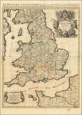
Nice example of a relatively uncommon map of the southern half of Great Britain, showing England and Wales and colored by region. Following London publisher John Cary's model, as well as other sources quoted including Conrad Mannert, the map includes a substantial amount of detail.
Relief, canals, cities, towns, rivers, and much more are all shown. Particularly interesting, however, are the roads that connect the various towns and allow for an understanding of how these population centers were linked.
This map was published only just before the failed French invasion of Britain in February of 1797 when Revolutionary forces landed on the Welsh coast.
The map is attractively colored by region, including East Anglia, Wales, Yorkshire, Kent, and the West Country. This is the first time we have offered this map for sale.
![[ London To Portsmouth ] The Road from London to Portsmouth in com: Southamp: Actually Surveyed & Delineated . . . .](https://storage.googleapis.com/raremaps/img/small/98935.jpg)