|
||

|

|
|

|
Stock# 78779
Description
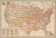
Detailed wall map of the United States issued by the Hamburg-American Line (HAPAG) to illustrate their routes and connecting routes to and within the United States and Canada.
The key differentiates between passenger and freight versus pleasure trip routes operated by HAPAG.
The map also designates Indian Reservations and National Parks.
The national highways do not seem to be numbered, indicating a date before 1926, but this is not well established, and the map could be from the 1930s.
Condition Description
Some wear at old folds, including small spots of loss, backed with linen on the verso.
![Colton's United States Shewing Military Stations, Forts &c. . . . 1861 [Shows Slave, Free and Border States -- Printed For British Market]](https://storage.googleapis.com/raremaps/img/small/103234.jpg)
![[ US-Mexico Border Survey: General Order From the President of the United States Directing William H. Emory to lead the US-Mexico Boundary Survey ]](https://storage.googleapis.com/raremaps/img/small/101837.jpg)