|
||

|

|
|

|
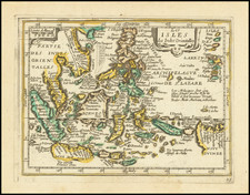
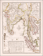
Detailed map of Southeast Asia, bounded by Taiwan in the north, Cambodia, the Straits of Malacca, Sumatra the northwest coast of Australia, and the Ladrones, and centered on the Philippines. The map is attractively designed according to 17th-century French sensibilities, including a simple neoclassical cartouche and artfully understated detail.
The map shows the Philippines, Indonesia, and the Malaysian Peninsula naming cities and more. Ihor (Jahor) is named, and the "Sincapura" River is named. Place names are included in Taiwan.
This was one of the earliest maps of the region printed in a French atlas.
Nicholas Sanson (1600-1667) is considered the father of French cartography in its golden age from the mid-seventeenth century to the mid-eighteenth. Over the course of his career he produced over 300 maps; they are known for their clean style and extensive research. Sanson was largely responsible for beginning the shift of cartographic production and excellence from Amsterdam to Paris in the later-seventeenth century.
Sanson was born in Abbeville in Picardy. He made his first map at age twenty, a wall map of ancient Gaul. Upon moving to Paris, he gained the attention of Cardinal Richelieu, who made an introduction of Sanson to King Louis XIII. This led to Sanson's tutoring of the king and the granting of the title ingenieur-geographe du roi.
His success can be chalked up to his geographic and research skills, but also to his partnership with Pierre Mariette. Early in his career, Sanson worked primarily with the publisher Melchior Tavernier. Mariette purchased Tavernier’s business in 1644. Sanson worked with Mariette until 1657, when the latter died. Mariette’s son, also Pierre, helped to publish the Cartes générales de toutes les parties du monde (1658), Sanson' atlas and the first French world atlas.