The item illustrated and described below is sold, but we
have another example in stock. To view the example which
is currently being offered for sale, click the
"View Details" button below.


|
||

|

|
|

|
Stock# 7862
Description
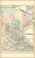
Massive map of Minnesota, colored by townships and showing railroads, canals, post offices, stations, etc. One of the best large format commercial atlas maps of the era. From one of the leading American map publisher of the 1870s.
O.W. Gray Biography
O. W. Gray was a publishing firm based in Philadelphia. Later, they published as O. W. Gray & Son. They published atlases in the late nineteenth century. Gray's National Atlas was one of the most successful commercial ventures of the 1870s and one of the last to employ hand coloring on maps.

![[ Transatlantic Cable and Transcontinental Railroad ] Kaart van de eerste (Engelsche en Fransche) telegraaf-kabels tusschen Europa en Amerika (and) Kaart van den Union Pacific-Spoorweg van Chicago naar San-Francisco](https://storage.googleapis.com/raremaps/img/small/105775.jpg)