|
||

|

|
|

|
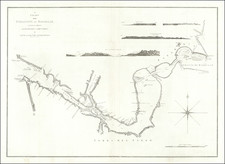
Iquique Harbor Shortly After The Battle of Iquique
Rare sea chart of the harbor of Iquique, Chile and the area just to the north, with a large plan of Iquique, published by the French Service Hydrographique de La Marine in Paris.
This is one of the earliest survivng maps to treat Iquique with any degree of detail, with OCLC locating several other maps between 1880 and 1887, each surviving in 1 or 2 examples recorded by OCLC.
The Isla Serrano is still shown as an island, with a detailed plan of Iquique noting several buildings, including a Tower, Cathedral, train station, hospital, wharf, train wharf, etc. Anchorages and buoys are shown, as are soundings and other details.
North of Serrano, the anchorage of warships is noted, with the location of the wreck of the Esmeralda shown furthern north. Esmeralda was a Chilean Nave steam corvette, which sunk by a Peruvian ship during the Battle of Iquique in May 1879.
Iqueque
Iqueque was founded in the 16th century, as part of the Viceroyalty of Peru. It remained a part of Peru until the 19th Century. Iquique's early history relates to its mineral wealth in the neighboring the Atacama Desert.
In July 1835, Charles Darwin visited Iquique and described it as a town "very much in want of everyday necessities, such as water and firewood".
On several occasions, the city has been devastated by earthquake, including the 1868 Arica earthquake, the 1877 Iquique earthquake, shortly before this chart was made.
In 1879, Bolivia and Chile fought the War of the Pacific in 1879, which included a May 21, 1879 battle in the harbor of Iquique.
Rarity
OCLC locates a single example (Cambridge University).
![[Chile] Chili](https://storage.googleapis.com/raremaps/img/small/102114.jpg)