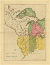
|
||

|

|
|

|
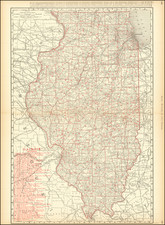
Chapman's Sectional Map of Illinois, published by Silas Chapman in Milwaukee, Wisconsin in 1856, provides a meticulously detailed portrayal of Illinois during a pivotal moment in the state's development. The map, lithographed by Ferd. Mayer & Co. of New York, distinctly distinguishes between ongoing and completed railroad constructions, signifying the rapid infrastructural changes sweeping through the region. With the counties vividly hand-colored, the map showcases the outcomes of township surveys, highlighting county seats, rivers, canals, common roads, and various topographical nuances.
The 1850s marked an era of profound growth and transformation for Illinois. With the state becoming a hub for railway expansion and infrastructural development, it attracted an influx of settlers, industries, and economic opportunities. Chapman's map provides a window into this transformative era, particularly illuminating the budding railway network that would soon crisscross the state, linking towns, spurring economic growth, and catalyzing Illinois' integration into the broader national economy.
The prominence of railroads, both completed and in progress, underscores the significance of these transport routes in enhancing connectivity and commerce. Railroads, seen as technological marvels of their time, revolutionized not only transportation but also the socio-economic landscape of the region. The map's distinction between "Rail Road in Progress" and those "Completed" showcases the dynamic nature of this development.
The inclusion of "Swamp Lands" and "Canal" in the explanations section paints a picture of the state's varied geographical features and the challenges they posed. These labels hint at both the natural resources available and the logistical hurdles overcome during Illinois' growth.
The detailing of county towns, villages, and common roads further indicates Chapman's commitment to offer a comprehensive geographical resource. It serves as a testament to the cartographic precision of the mid-19th century and stands as an invaluable record of Illinois during an era of rapid change and progress.
![[ Mississippi River Atlas ] Theorie der Bewegung des Wassers in Flüssen und Canälen. . . . (Atlas Volume)](https://storage.googleapis.com/raremaps/img/small/101700.jpg)