


|
||

|

|
|

|
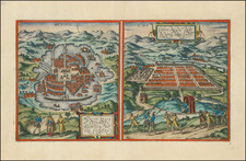
An exceptionally attractive example of Braun & Hogenberg's views of Mexico City and Cusco, among the earliest printed views of any American city. Published in Bruan and Hogenberg's monumental city atlas, Civitates Orbis Terrarum, these are the only two American views to be included.
The Mexico City view shows it on the still undrained Lake Tenochtitlan, connected by many walkways to the mainland. In the background, European-style shrubbery gives way to high mountains.
In contrast to the Mexican view, Cuzco is presented as an orderly city with a great palace at the outside. Each view includes indigenous scenes at the front of the image.
Georg Braun wrote the following commentary on Mexico City, translated here:
Mexico, or Tenochtitlan, is a rich and important city in New Spain in the Mexican provinces, lying in a saltwater lake. There are many heathen temples here, which their priests live in; the most important amongst them is a temple whose quite incredible magnificence is described in detail by Hernan Cortés. They make their heathen images out of flour and human blood, and every day sacrifice a large number of human hearts to them, which they cut out of the living bodies. A magnificent palace belonging to the most powerful lord, Moctezuma, also stands here.
A translation of his commentary on Cusco follows:
The capital of Peru in the south of the New World is Cusco, a city so large, powerful, and beautiful that it can easily rank alongside the most important cities in Spain and France [...] The streets are generally very straight with numerous crossroads and a stream flows down most streets. The city is particularly embellished by a wonderful palace that lies on a steep hill and has no comparison in Europe.
Civitates Orbis Terrarum: The Greatest City Book
Georg Braun and Frans Hogenberg began the process of creating a comprehensive atlas of the cities of the world in 1572. Their book, Civitates Orbis Terrarum, was originally intended as a companion to Abraham Ortelius's Theatrum Orbis Terrarum, the first true atlas.
The great atlas was edited by Georg Braun, with Franz Hogenberg engraving many of the views. When the project was finished, the series would contain over 546 views (sometimes with multiple views on a single plate).
Civitates Orbis Terrarum includes the work of over 100 artists and topographers, perhaps most notable among them was the superlative talent of Joris Hoefnagel (1542-1600). He provided original drawings of Spanish and Italian towns, as well as reworking and improving the town drawings of other artists. After Joris's death, his son Jakob continued the project.
The Civitates provides an incredibly comprehensive view of urban life in the late 16th century. Many of the views in these volumes are the earliest of their respective towns -- either absolutely, or they are predated only by impossible rarities, as in the case of London. Cities portrayed range from the great capitals of Europe, Asia, Africa, and the Americas to small Swiss hamlets and other tiny villages. As such, this singular and indispensable source for understanding the early modern world.
The work was published in six volumes, each of which contained approximately sixty plates. The subject matter of each plate varied widely, it could provide a single view of a city, two views of the same city, or views of up to nine different cities. The range of designs is extensive, and it is interesting to compare the variety between views of the same city by two different authors.
Georg Braun (1541-1622) was born and died in Cologne. His primary vocation was as Catholic cleric; he spent thirty-seven years as canon and dean at the church St. Maria ad Gradus, in Cologne. Braun was the chief editor of the Civitates orbis terrarum, the greatest book of town views ever published. His job entailed hiring artists, acquiring source material for the maps and views, and writing the text. In this role, he was assisted by Abraham Ortelius. Braun lived into his 80s, and he was the only member of the original team to witness the publication of the sixth volume in 1617.
Frans Hogenberg (ca. 1540-ca. 1590) was a Flemish and German engraver and mapmaker who also painted. He was born in Mechelen, south of Antwerp, the son of wood engraver and etcher Nicolas Hogenberg. Together with his father, brother (Remigius), uncle, and cousins, Frans was one member of a prominent artistic family in the Netherlands.
During the 1550s, Frans worked in Antwerp with the famous mapmaker Abraham Ortelius. There, he engraved the maps for Ortelius’ groundbreaking first atlas, published in Antwerp in 1570, along with Johannes van Deotecum and Ambrosius and Ferdinand Arsenius. It is suspected he engraved the title page as well. Later, Ortelius supported Hogenberg with information for a different project, the Civitates orbis terrarium (edited by Georg Braun, engraved by Hogenberg, published in six volumes, Cologne, 1572-1617). Hogenberg engraved the majority of the work’s 546 prospects and views.
It is possible that Frans spent some time in England while fleeing from religious persecution, but he was living and working in Cologne by 1580. That is the city where he died around 1590. In addition to his maps, he is known for his historical allegories and portraits. His brother, Remigius, also went on to some fame as an engraver, and he died around the same time as his brother.
![[ Baja California / Gulf of California ] Carta Esferica de las Costas y Golfo De Californias Llamado Mar De Cortes Que Comprende desde el Cabo Corrientes hasta el Puerto de San Diego Construida …. 1825](https://storage.googleapis.com/raremaps/img/small/102732.jpg)
![[ Yucatan ] Karte der Halbinsel Yucatan, hauptsächlich nach der von Joachim Hubbe und Andres Aznar Perez zusammengestellten und von C. Hermann Berendt revidirten und vermehtren Mapa de la Peninsula de Yucatan von 1878](https://storage.googleapis.com/raremaps/img/small/96420.jpg)