|
||

|

|
|

|
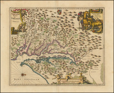
Revolutionary War-Era Map of Hilton Head and Surroundings.
Rare French edition of Captain John Gascoigne's foundational chart of Port Royal and vicinity, revised and issued in Le Rouge's Pilote Americain Septentrionale, which was compiled specifically for use by the French Navy during the American Revolution.
Gascoigne's sea chart was the most important map of Port Royal Sound and Hilton Head made during the Revolutionary War. The map illustrates much of modern Beaufort County. The Broad River enters from the north, and the sound is bordered by Port Royal, Parris, and Trench's (Hilton Head) Island, as well as Lady's and Saint Helena Islands. The City of Beaufort appears at the top, along with a number of plantations, each of which is named.
Captain John Gascoigne led an extensive charting of the Carolina coastline in 1728, aboard the HMS Alborough. Gascoigne's chart would later be revised and refined in 1729 by Francis Swaine. In the tradition of the 18th century, Swaine or one of his successors supplied a copy of the map to London chartmaker William Faden, who published the chart in 1776 for use by the British during the American Revolution.
The chart was revised by Le Rouge and included in Le Rouge's rare North American pilot, an atlas of sea charts compiled by the French government and utilized by the French Navy during their participation in aid of the Americans during the American Revolutionary War.
Rarity
Le Rouge's chart is rare on the market (even more so than the original Gascoigne edition), with no examples listed in AMPR in the past 30 years.
George-Louis Le Rouge (1712-1790), though known for his work in Paris, was originally born Georg Ludwig of Hanover, Germany. He grew up and was educated in Hanover, after which he became a surveyor and military engineer. Around 1740, however, Le Rouge moved to Paris and set up shop as an engraver and publisher on the Rue des Grands Augustins. It was at this time that he changed his name, adopting a French pseudonym that would later become quite famous.
Le Rouge spent much of his forty-year career translating various works from English to French, and his cartographic influence often came from English maps. His experience as a surveyor and engineer in Germany made him a skilled and prolific cartographer, and he produced thousands of charts, maps, atlases, and plans. His work spans from garden views and small-town plans to huge, multiple-continent maps. Le Rouge eventually accepted the position of Geographical Engineer for Louid XV, the King of France.
Later in life, Le Rouge became well-known for publishing North American maps, such as in his Atlas ameriquain septentrional of 1778. One of Le Rouge’s other more famous works is the Franklin/Folger chart of the Gulf Stream, which he worked on with Benjamin Franklin. Franklin and Le Rouge corresponded around 1780 and collaborated to create this map, a French version of Franklin’s famous chart which was originally printed in 1769.