|
||

|

|
|

|
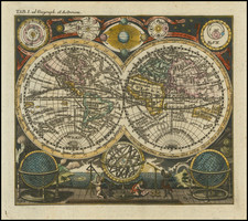
Decorative map of the world on Mercator's projection with an attractive cartouche showing various cartographic and surveying instruments.
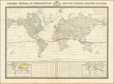
This map is particularly appealing due to its non-standard geographic perspective, with Australia and the Pacific at the center of the map. This allows for the "Grand Ocean Boreal" (Pacific) to be shown in its vast entirety, with many archipelagos labeled. This includes the Sandwich Islands (Hawaii) and the "Low Islands or the Dangerous Archipelago" (western French Polynesia).
The majority of the world map is filled in a manner recognizable today, although the polar regions still require some refinement. Baffin Bay is still closed, the northern coast of Alaska is left blank, and several northern Canadian rivers empty into a suggested "lake or ocean." New Siberia, explored by Ivan Lyakhov in the 1770s, is shown as a large landmass, instead of as a collection of islands. Northeast of Spitsbergen is a supposed coastline described by the Dutch.
This fine map displays Malte-Brun's unique and attractive style. His maps are prized for their decorative quality and classic attention to detail without being overwhelming.
![[World] Air France](https://storage.googleapis.com/raremaps/img/small/67997.jpg)