|
||

|

|
|

|
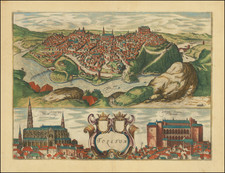
Handsome example of Braun & Hogenberg's antique engraved view of Santander, Spain.
Santander and its surrounding bay are shown from the northeast. The image is dominated by the harbor, which indicates the importance of this city for trade in the region of Cantabria; after the discovery of America, trade with the New World took on great proportions.
Behind the harbor, the primary monument is the Iglesia colegial de los Cuerpos Santos, in which the bones of Saint Emeterius are kept; he was an early Christian martyr from whom the name Santander is derived.
Georg Braun's commentary translated to English reads:
The city of Santander lies in Hispania Tarraconensi on the Atlantic. [...] On the left, the sea comes right up below the walls and is channeled into the city through a ford. Here they have built a wall with human artistry and thus created a harbour shaped like bent arms. At the end of this wall a crane, in their language la grúa, has been erected, with which they can lift great loads.
Georg Braun (1541-1622) was born and died in Cologne. His primary vocation was as Catholic cleric; he spent thirty-seven years as canon and dean at the church St. Maria ad Gradus, in Cologne. Braun was the chief editor of the Civitates orbis terrarum, the greatest book of town views ever published. His job entailed hiring artists, acquiring source material for the maps and views, and writing the text. In this role, he was assisted by Abraham Ortelius. Braun lived into his 80s, and he was the only member of the original team to witness the publication of the sixth volume in 1617.
Frans Hogenberg (ca. 1540-ca. 1590) was a Flemish and German engraver and mapmaker who also painted. He was born in Mechelen, south of Antwerp, the son of wood engraver and etcher Nicolas Hogenberg. Together with his father, brother (Remigius), uncle, and cousins, Frans was one member of a prominent artistic family in the Netherlands.
During the 1550s, Frans worked in Antwerp with the famous mapmaker Abraham Ortelius. There, he engraved the maps for Ortelius’ groundbreaking first atlas, published in Antwerp in 1570, along with Johannes van Deotecum and Ambrosius and Ferdinand Arsenius. It is suspected he engraved the title page as well. Later, Ortelius supported Hogenberg with information for a different project, the Civitates orbis terrarium (edited by Georg Braun, engraved by Hogenberg, published in six volumes, Cologne, 1572-1617). Hogenberg engraved the majority of the work’s 546 prospects and views.
It is possible that Frans spent some time in England while fleeing from religious persecution, but he was living and working in Cologne by 1580. That is the city where he died around 1590. In addition to his maps, he is known for his historical allegories and portraits. His brother, Remigius, also went on to some fame as an engraver, and he died around the same time as his brother.
![[Barcelona] Barcino Metropolis Hispanici Principatus Cataloniae in littore Maris Mediterranei, perquam munita, et ab portus como ditatem celeberrimum Emporium cura Impensis . . .](https://storage.googleapis.com/raremaps/img/small/90953.jpg)
![[Cadiz / Columbus's Point of Departure] Gades Ab Occiduis Insulae Partibus](https://storage.googleapis.com/raremaps/img/small/79538.jpg)