|
||

|

|
|

|
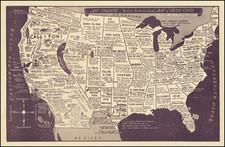
One of the earliest obtainable large format coast to coast maps of the United States, which was likely issued separately, although also bound into large composite atlases of the period.
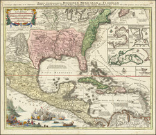
Herrison's map is a marvelous blend of up to date cartographic details, western cartographic myths and interesting geo-political boundaries. In the West, there are two Salt Lakes (Timanagos and Teguayo), each connected to the Pacific by a mythical river. Several of the mythical rivers in Southern California and Arizona, west of the Colorado River, are still shown. In the north, the American boundary ambitions, claiming the lands drained by the Fraser River, are illustrated, as are note showing MacKenzie's discoveries in the region and many of the Hudson's Bay Forts and Factories in Western Canada.
The map provides an excellent post Lewis & Clark depiction of the so-called District De La Colombie (Oregon Territory), including many Indian Tribes, accurate river placements, and a tracing of the Lewis & Clark route, from the headwaters of the Missouri River to the Columbia River and back, one of the few maps to trace the route. Several places along the Route are named, including Canoe Camp and Travellers. The different routes taken by the Lewis & Clark expedition on the return trip to the East are also noted separately, as is a point of Observation on the Marie River. A number of early Forts and Trading Posts are also noted in the region. Other Lewis & Clark notes appear in the Missouri River Valley.
The Rocky Mountain configuration is based on Humboldt and Pike. The early road / train systems in the West from Santa Fe to the Salt Lake area is depicited, along with Missions. In Texas, the site abandoned by Champ D'Aisle is noted, as is the Presidio and Texas Capital. Double wide Arkansas and the Spanish Land Districts of Howard, St. Louis, Laurence, and Arkansas are shown West of the Mississippi.
Between the Mississippi River and the Rocky Mountains, a massive area noted at "Haute Louisiana" (Upper Louisiana) is noted. A tremendous post-Melish map, reflecting the American ambition of manifest destiny.
![A Map of North America, Constructed According To The Latest Information: by H.S. Tanner. Improved to 1825 [Case Map]](https://storage.googleapis.com/raremaps/img/small/68580.jpg)
![[Eurpean and American Air Routes] TWA Trans World Airline U.S.A. • Europe • Africa • Asia Air Routes](https://storage.googleapis.com/raremaps/img/small/89027.jpg)