|
||

|

|
|

|
Stock# 77709
Description
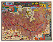
Classic pictorial map of Cape Cod, Massachusetts, made by F.J. Miller and typically dated to around 1950.
The map covers all of the Cape, to Provincetown, Buzzards Bay, Plymouth Bay, etc. An attractive decorative border surrounds the central map image, and it is filled scenes of sporting and local recreation.
The map is scarce. OCLC locates only one institutional example.
Condition Description
Archivally backed on modern poster linen. Restoration of some minor faults at the edges.
![[Limited Edition of 33] The Sculpture & Art of Jo Mora](https://storage.googleapis.com/raremaps/img/small/94900.jpg)