|
||

|

|
|

|
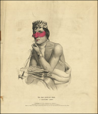
Fine hand-colored aquatint landscape of the colliery near the then frontier settlement town of Mauch-Chunk (now Jim Thorpe, Pennsylvania), which grew up around the local mining industry. The area was described by Maximilian in his journal: “
On the right or southern wall, a railroad comes from one of the collieries of the Mauch Chunk Company… as far as to the valley of the Lehigh, and then turns to the right towards Mauch Chunk,… The railroad is constructed of parallel pieces of wood, upon which the iron rails are fastened… In order to save expenses, a single road was built, so that wagons running up and downward have to use the same tracks, and accidents may easily happen.
Maximilian’s monumental account first appeared in German (1839-41), followed by a French translation in 1840-43 and an English edition in 1843. A Paris-issued pictorial atlas contained eighty-one aquatint plates (48 "imperial" folios and 33 smaller "vignette" plates often called quarto in size), engraved and etched on metal plates, after paintings by Karl Bodmer, and which accompanied all three editions. The plates are outstanding authentic depictions of the western plains and Native Americans by a highly skilled European artist. Bodmer avoided romanticizing his subjects, and attempted to record the people and places he encountered as true to life as possible.
This landscape print has the three captions and imprint statements in German, French, and English.
Includes the special blindstamp with Bodmer's name which is requisite on first issues of the larger folio plates.
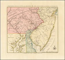
![[4 Colonial and 18th Century Manuscript Surveys on the Delaware River]](https://storage.googleapis.com/raremaps/img/small/89416.jpg)
![[Uncaptioned image of two figures seated in front of a tipi, mounted albumen print]](https://storage.googleapis.com/raremaps/img/small/78744.jpg)