


|
||

|

|
|

|
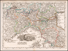
Scarce map of the Piedmont region of Italy, first published in Paris by Pierre Mariette in 1658.
The map is centered on the area around on Turin and extends from Antibes on the French coast to Savona.
Nicolas Sanson's 'Les Cartes Generales' was first published in 1658. This map was introduced in 1665, this example is a later state with the imprint changed.
Sanson was France's premier cartographer and helped to lift French work in this area to another level. His atlas is the first full world atlas to be produced in France.
Nicholas Sanson (1600-1667) is considered the father of French cartography in its golden age from the mid-seventeenth century to the mid-eighteenth. Over the course of his career he produced over 300 maps; they are known for their clean style and extensive research. Sanson was largely responsible for beginning the shift of cartographic production and excellence from Amsterdam to Paris in the later-seventeenth century.
Sanson was born in Abbeville in Picardy. He made his first map at age twenty, a wall map of ancient Gaul. Upon moving to Paris, he gained the attention of Cardinal Richelieu, who made an introduction of Sanson to King Louis XIII. This led to Sanson's tutoring of the king and the granting of the title ingenieur-geographe du roi.
His success can be chalked up to his geographic and research skills, but also to his partnership with Pierre Mariette. Early in his career, Sanson worked primarily with the publisher Melchior Tavernier. Mariette purchased Tavernier’s business in 1644. Sanson worked with Mariette until 1657, when the latter died. Mariette’s son, also Pierre, helped to publish the Cartes générales de toutes les parties du monde (1658), Sanson' atlas and the first French world atlas.
![Stato Di Milano Parte Occidentale [and] Stato Di Milano Parte Orientale](https://storage.googleapis.com/raremaps/img/small/94602.jpg)