


|
||

|

|
|

|
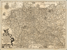
The Invasion of Poland Postcard
An interesting piece of pro-German persuasive cartography aimed at an American audience in the lead-up to the Second World War.
This postcard attempts to elicit sympathy for the post-World War I "plight" of Germany by asking an American audience how they would feel about Maine being cut off from the rest of the country through the annexation of New Hampshire and an independent state at Boston.
The map asks the American reader:
What would you say if the United States of America were to be treated in this way and made to look like Germany does as shown in the accompanying map? Would the United States be willing to agree to such frontiers?
A related postcard was distributed in the United Kingdom, showing Britain cut in two by a corridor originating from the port city of Hull.
Evidently, the postcards were mailed to recipients in the U.S. and U.K. in the summer of 1939. The first of the postcards arrived in the United States on August 26, 1939, the date on which Hitler had initially intended to begin the invasion of Poland.
It would seem that German propagandists had hoped that these postcards would blanket the U.S. and U.K. just as news of the German invasion was spreading. As it was, the German invasion didn't begin until September 1st.
![Carte Du Canada ou de la Nouvelle France et des Decouvertes qui y ont ete faites . . . [Map of Canada or New France and the Discoveries Made Therein . . .]](https://storage.googleapis.com/raremaps/img/small/94450.jpg)
![(World War II) [Iwo Jima Aerial Reconnaissance Photograph, March 8, 1945]](https://storage.googleapis.com/raremaps/img/small/83776.jpg)