


|
||

|

|
|

|
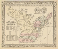
A charming historical map, showing the 13 colonies, Indian Tribes, and details dating to 1776, along with other important historical facts, populations, and Revolutionary War battle dates.
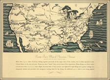
A marvelous little map produced on the 100 year anniversary of the Declaration of Independence.
An unusual historical map of the Colonies, the only map of its kind issued in a commercial atlas in the late 19th Century.
Samuel Augustus Mitchell Jr. inherited the Mitchell Company from his father in 1860. For over thirty years, the company had specialized in the production of school atlases and wall maps of America. They were one of the pioneers on engraving on steel plates. In 1860, Samuel Jr. released the New General Atlas, which had been compiled in house and replaced a previous atlas by Tanner. The elder Mitchell died in 1868 and Samuel Jr. continued the business until the 1890s. At its height, the Mitchell Company employed 250 people and sold 400,000 publications annually.
![A New and Exact Map of the Dominions of the King of Great Britain on ye Continent of North America . . . [Beaver map]](https://storage.googleapis.com/raremaps/img/small/101277.jpg)