


|
||

|

|
|

|
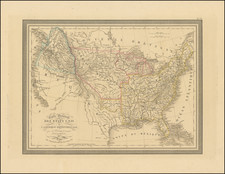
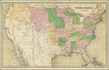
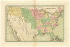
The Earliest Traced American Electoral Map Apportioning Results by District. One Known Example.
Hand-colored lithographed folding map showing the congressional districts and party representation for the 45th United States Congress. This map, coloring districts red for Democrats and blue for Republicans, represents the earliest electoral map of the U.S. that shows the results of a recent election of the House of Representatives and the most informative electoral map published to date.
Susan Schulten, of the University of Denver, has called a later 1880 map the earliest traced map to show the returns of a U.S. presidential election, although this term is ambiguous. Thorough research of earlier maps in the Library of Congress collection and other databases reveal that the results of presidential elections had been charted on a statewide level in rudimentary maps since at least 1848. We have previously had a map published a year before the one presented, in 1877, that shows the results of the first nineteen elections. However, the visual information on all of these earlier maps is substantially less than that seen in the map presented here.
This 1878 map reports on a district-by-district level the results of an election in which the winners were still in office, and is thus substantially more detailed and was substantially more important in shaping the national consciousness when it was published. This dissemination of information represents a new way of the public following elections, in which a national audience paid close attention to the country-wide geopolitical scene. This map was published just before the 1878 midterms, a time at which this information regarding the most recent national election would have been particularly important.
This map is a critical cartographic landmark in mapping the political history of the United States.
The Map
The map is a fantastic century-and-a-half predecessor to the political maps we see on CNN on FiveThirtyEight. While the South is red and the Northeast is blue, the colors are inverted from the parties they are associated with today. The map shows all the congressional districts of states and leaves uncolored territories that have not yet achieved statehood. Due to the smaller sizes of districts in the eastern part of the country, and the more intricate detail required to show them, the map is split in two with the eastern states roughly double the size of their western counterparts.
For the biggest cities, the map includes eight insets showing New York, Baltimore, Philadelphia, Boston, St. Louis, Cincinnati, New Orleans, and San Francisco. With the exception of St. Louis and Chicago, these cities are for the most part Democrat-controlled. The map includes a number of tables listing the representatives of each state, the party affiliation of governors, the number of votes according to party per state, and President Rutherford Hayes's cabinet.
This map was published in Chicago by Charles L. Driesslein, a Chicago-based German-born stenographer who appears to have entered the publishing business. We have been unable to trace the existence of W. E. Vigus, and this is the only recorded work that this author appears to have executed.
Texas "Territories"
Interestingly, in Texas, the map names "Territory of Young" and "Territory of Bexar". These were place-holder organizing structures used before the land was subdivided into counties. The use of "Territory of Bexar" is anachronistic for 1878, as all of that land had been divided into counties four years earlier. In fact, much of what is shown as "Territory of Bexar" was never in the Bexar Land District, having immediately been divided into Presidio and El Paso Counties, when county division reached that far west for the first time in 1850.
The 1876 Election
The 1876 elections for the 45th Congress saw a split legislative-executive divide, with the Republican Rutherford Hayes winning the federal election, Republicans winning the Senate, and Democrats winning the House. While the presidential election was marred by Hayes losing the popular vote and several results being highly contested, the election of the house appeared to have run smoothly.
The election produced a Congress very opposed to Reconstruction, and the House passed an army expropriations bill that would have effectively ended the program, vetoed by Hayes. Despite Hayes's opposition, the failure of Congress passing any funds to enforce civil rights laws made any attempts by Hayes to preserve racial freedoms in the South futile. The Great Railroad Strike and a debate of the end of the silver currency were other major issues of his term.
The 1878 midterm would see an increase in Democratic legislative power, but the Republicans would keep the presidency in 1880 after Hayes stepped down, as promised, after a single term.
Rarity
We were able to trace only one example of this map, at the Wisconsin Historical Society. We are unable to trace any other examples of this map having traded on the market. All political maps from this era are very rare.


![[United States] Etats-Unis](https://storage.googleapis.com/raremaps/img/small/62774.jpg)