|
||

|

|
|

|
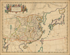
Russian-Language Map of Korea from the Russo-Japanese War.
Impressive Russian-language map of the Korean peninsula and adjacent parts of Russia and China, issued in St. Petersburg in 1904.
The map includes extensive transliterations of Korean and Chinese toponyms and points of interest into Russian. The map names cities, villages, rivers, railways, telegraph cables, ports administrative areas, and bays.
The Staff Topographical Bureau, founded in 1822, was the main service of military mapmaking in the Russian Empire – in fact, after some reorganizations – it continues in the role in present-day Russia. The Bureau was responsible for enormous work of innovative mapping of the Russian Empire and other countries. In the late 19th century, around 500 people were enlisted as officers of the Bureau.
Provenance
The map descended in the family of a Kronstadt Fleet naval officer, who participated in the Russo-Japanese War. Apparently, the map traveled to the East aboard a ship that went to the region from St. Petersburg in 1904. Some cities and railway stations are hand-marked - possibly for relating to field operation planning. It is known that in 1904-1905 71 Russian battleships were fighting against 89 Japanese battleships within two main areas: the Yellow Sea and the Sea of Japan.
Background: Russo-Japanese War
From the late 19th century, the Russian Empire planned to establish a huge colony in the East called Zheltorossiya (Yellow-Russia). The idea was to capture part of China, Tibet, Korea, and other territories available for annexation and expand the Empire considerably with a line of sea fortresses. By coincidence, the Japanese Empire had similar interests simultaneously. After a series of unsuccessful negotiations over the Manchuria region, the Russo-Japanese War erupted.
The map shows the main point of interest in the Russian-Japanese War, Port Arthur (also named by the original Chinese name Lu-shun-kou): a city that was the outpost of the Russian Empire from 1904. With the help of army presence and large bribes, in the Spring of 1898, the Russian Empire pushed China into a treaty and a 25-year lease agreement of the Kwantung area. In 1903, the Kwantung area became part of the Russian Dalnevostochnoye namestichestvo. Port Arthur was in the early stages of its development and fortification as a military base, when it was attacked by the Japanese Imperial Army in January of 1904. The Russo-Japanese War would last for a year and a half as the two empires attempted to carve up the Eastern territories. The War ended with the signing of the Treaty of Portsmouth, curbing Russia's imperial ambitions in the East. The war saw the deployment of over half a million soldiers from both sides. The War had concluded with Japanese victory and was devastating for the Russian Empire, which had already rolled its sleeves up and soaked its arms in the blood of revolution.
Rarity
Although the available sources state there were 4,000 copies of the map printed, none except this one survive anywhere in the West – including in the main Russian libraries.
Not in WorldCat. Not in RSL. Never offered for sale on any tracked Russian auction.
We extend our thanks to Pavel Vedernikov for his research on this map.
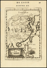
![La Tartaria Chinese . . . 1784 [show Corea]](https://storage.googleapis.com/raremaps/img/small/97766.jpg)