|
||

|

|
|

|
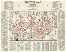
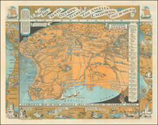
Early Development Map of Beverly Hills
Rare early "sales map" of the Rodeo Land & Water Company, published in about 1917-1918.
The map provides a remarkable snaphot of the recently incorporated Beverly Hills (incorporated in 1914), including pencil annotations showing lot prices (mostly on Rodeo Drive, Bedford Drive, Alpine Driver and Foothill Road, along with numerous other pencil notes, which were likely related to the cost of construction of homes, etc.
On the verso of the map is a hand drawn map showing North Maple Drive in Beverly Hills, between Clifton Way and Wilshire Blvd and a short section of North Crescent Drive, at the intersection of Clifton Way, including lot prices and sold lots. Additional notes and numbers are given describing a transaction on Rexford with the WC Campbelle Company (417 Beverly Drive).
Dating The Map
While the map is undated, there are seveal possible clues. The 1918 Official Map of the City of Beverly Hills is a good refererence point: https://hdl.huntington.org/digital/collection/p15150coll4/id/2795
The map identifies "City Park" below the Beverly Hills Hotel. The hotel was completed in 1912. The park was purchased by Margaret Anderson in 1915 and donated to the City of Beverly Hills, ultimately becoming Will Rogers Memorial Park.
The map identifies the Beverly Hills School, now Hawthorne Elementary School, which was started created in 1913 and the Auditorium (not shown on the map) was built in 1921.
Between Sunset, Hillcrest and Doheny Road, there are 2 lots shown, whereas on the 1918 Official Map, ther are now 6 lots. By contrast, there are several areas in the Official map which appear to show less subdivision than the present map.
The earliest construction work on Rexford Drive occurred in about September 1920. The first lot sales report in the Los Angeles Times on March 7, 1920.
Predecessor to this map: www.raremaps.com/gallery/detail/52435bb/sales-map-of-property-of-rodeo-land-and-water-co-in-beverly-rodeo-land-and-water-co
Beverly Hills
The area which would become Beverly Hills was first settled by Maria Rita Quinteros de Valdez and her husband in 1828, who acquired a 4,500 acre land grant which became Rancho Rodeo de las Aguas. In 1854, Quinteros sold the Rancho to Benjamin Davis Wilson (1811-1878) and Henry Hancock (1822-1883). By the 1880s, the ranch had been subdivided into parcels of 75 acres.
Henry Hammel and Andrew H. Denker acquired most of the Rancho and used it for farming lima beans. At this point, the area was known as the Hammel and Denker Ranch. By 1888, Denker and Hammel were planning to build a town called Morocco on their holdings.
In 1900, a large syndicate, including Burton E. Green, Charles A. Canfield, Max Whittier, Frank H. Buck, Henry E. Huntington, William G. Kerckhoff, William F. Herrin, W.S. Porter, and Frank H. Balch, formed the Amalgamated Oil Company, bought the Hammel and Denker ranch, and began looking for oil, but with out much success. In 1906, the syndicate reorganized as the Rodeo Land and Water Company, renamed the property "Beverly Hills," subdivided it, and began selling lots. The development was named "Beverly Hills" after Beverly Farms in Beverly, Massachusetts and because of the hills in the area. The first house in the subdivision was built in 1907.
Burton Green began construction on The Beverly Hills Hotel in 1911. The hotel was finished in 1912. The visitors drawn by the hotel were inclined to purchase land in Beverly Hills, and by 1914 the subdivision had a high enough population to incorporate as an independent city.
In 1919, Douglas Fairbanks and Mary Pickford bought land on Summit Drive and built a mansion, finished in 1920 and nicknamed "Pickfair" by the press. The glamor associated with Fairbanks and Pickford as well as other movie stars who built mansions in the city contributed to its growing appeal. Gloria Swanson, Will Rogers, Thomas Ince, Charlie Chaplin, Tom Mix, Carl Laemmle, Ronald Coleman, King Vidor, John Barrymore, Buster Keaton, Harold Lloyd, Jack Warner, Clara Bow, Marion Davies, Harry Cohn and Rudolph Valentino soon followed and built their own mansions.
By the early 1920s the population of Beverly Hills had grown enough to make the water supply a political issue. In 1923, annexation to the city of Los Angeles was proposed. There was considerable opposition to annexation among such famous residents as Pickford, Fairbanks, Will Rogers and Rudolph Valentino. The Beverly Hills Utility Commission, opposed to annexation as well, managed to force the city into a special election and the plan was defeated 337 to 507.
In 1925, Beverly Hills approved a bond issue to buy 385 acres for a new campus for UCLA. The cities of Los Angeles, Santa Monica and Venice also issued bonds to help pay for the new campus. In 1928, the Beverly Wilshire Apartment Hotel (now the Beverly Wilshire Hotel) opened on Wilshire Boulevard between El Camino and Rodeo Drives, part of the old Beverly Hills Speedway. That same year oilman Edward L. Doheny finished construction of Greystone Mansion, a 55-room mansion meant as a wedding present for his son Edward L. Doheny, Jr. The house is now owned by the city of Beverly Hills.
In the early 1930s, Santa Monica Park was renamed Beverly Gardens and was extended to span the entire two-mile length of Santa Monica Boulevard through the city. The Electric Fountain marks the corner of Santa Monica Blvd. and Wilshire Blvd. with a small sculpture at the top of a Tongva kneeling in prayer. In April 1931, the new Italian Renaissance-style Beverly Hills City Hall was opened.
Rarity
The present map is unrecorded.