|
||

|

|
|

|
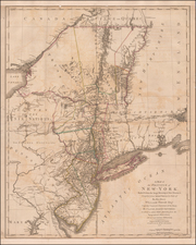
Nice example of John Reid's map of New Jersey, the second folio map of the state to appear in a commercial atlas.
The map is drawn largely from Carey's map by Samuel Lewis, issued the prior year.
An excellent topographical map, showing the counties, boundaries, principal towns, mountains, rivers, islands and many other details. Includes remarkable details, including land owners names and Indian Reservations.
John Reid's American Atlas was the second folio sized atlas published in the US. Reid's atlas, and was originally issued to accompany Winterbotham's Historical, Geographical, Commercial and Philosophical View of the United States. It was originally issued with 20 maps, which were engraved by Benjamin Tanner (9), David Martin (5), D. Anderson (2), John Scoles and John Roberts. Two of the maps are without credits.
Following Mathew Carey’s publication of the American Atlas in 1795, the second large format atlas published in America was produced by John Reid of New York in 1796. The project began as an atlas to accompany William Winterbotham’s An Historical, Geographical, Commercial and Philosophical View of the United States, but was also sold separately under the title The American Atlas.
Reid’s atlas included 20 maps. In addition, John Russell’s plan of Washington, D.C. is also bound into some copies of the Atlas. Reid’s atlas was a collaborative work, with 9 of the maps engraved by Benjamin Tanner, 5 by David Martin, two by D. Anderson and one each by John Scoles and John Roberts. Two of the maps do not include engraving credits. Each of the engravers was probably working in New York (including Tanner, who had not yet relocated to Philadelphia). According to the various entries for the maps in Wheat & Brun, the cartographic content of the maps is drawn largely from Carey’s first atlas of 1795.
![[Englewood, New Jersey] Commissoner's Sale of Real Estate! By virtue of an order of the Bergen County Orphan's Court . . . Saturday, April 20, 1889 . . . Englewood, N. J . . . Estate of J. L. Cooper . . .](https://storage.googleapis.com/raremaps/img/small/50595.jpg)
![New Jersey [with insets] Vicinity of Camden [and] Vicinity of Jersey City](https://storage.googleapis.com/raremaps/img/small/89264.jpg)