|
||

|

|
|

|
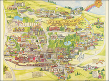
Devils Tower National Monument Wyoming Crook Co Special Topographic Map was published by the United States Department of the Interior Geological Survey in 1954. This map offers an exceptional glimpse into the unique geological and geographical configuration of the notable Devils Tower National Monument.
The map presents a comprehensive survey of the Devils Tower National Monument, a unique geological formation and the United States' first national monument established in 1906. It depicts various features with precision, including topographical contours, road classifications, and a delineation of the Devil's Tower. This intricate layout captures both the layout of human infrastructure and the underlying topographical details, reflecting a rigorous surveying method that accounts for physical geography and human impacts on the landscape.
This map situates within the broader historical context of mid-20th century American geological surveys and embodies the scientific and technological advancements of the time. The creation of the map, involving the use of plane-table methods in 1933 and revisions in 1949, illustrates the era's evolving techniques in surveying and cartography. The dedication of the USGS and USC&GS shines through the map's precision, providing accurate and exhaustive geographic data for both scientific and public use. As a result, this map serves as a valuable artifact from this critical period in the history of American geological surveying.
The "Devils Tower National Monument Wyoming Crook Co Special Topographic Map" symbolizes the intersection of geological science, human intervention, and the awe-inspiring natural wonders of the American landscape. Its historical significance, intricate detailing, and scientific underpinnings designate this map as a vital and intriguing document that reflects an iconic facet of the United States' physical and historical landscape.
![History of the Expedition under the Command of Captains Lewis and Clark, to the Sources of the Missouri Thence across the Rocky Mountains and Down the River Columbia to the Pacific Ocean, Performed During the Years 1804-5-6 [with map:] Map of Lewis and Clark's Track, Across the Western Portion of North America from the Mississippi to the Pacific Ocean](https://storage.googleapis.com/raremaps/img/small/92506.jpg)
![Map of Oregon, Washington and Part of Idaho [First Appearance Of Idaho Territory, including western Montana and Western Wyoming]](https://storage.googleapis.com/raremaps/img/small/94211.jpg)
![[Wall Map of Jackson Lake and Environs] Topographic Map of the Grand Teton National Park Teton County - Wyoming](https://storage.googleapis.com/raremaps/img/small/99907.jpg)