|
||

|

|
|

|
The Chinsurah Factory in Dutch Bengal
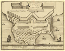
Nice example of Francois Valentijn's view of the town of Kochi on the Malabar Coast of India, which at the time was under the control of the Portuguese and served as a trading center.
The map is featured in Valentijn's Oud en Nieuw Oost-Indien, a significant history of the Dutch in Maritime Asia and one written with rare access to the Dutch East India Company (VOC) archives and information.
Kochi
The Portuguese first arrived in the area to Kappad Kozhikode in 1498 during the Age of Discovery, thus opening a direct sea route from Europe to India.
Portuguese navigator, Pedro Álvares Cabral founded the first European settlement in India at Kochi in 1500. From 1503 to 1663, Fort Kochi (known as Fort Emmanuel) was ruled by Portugal. Vasco da Gama, the first European explorer to set sail for India, was buried at St. Francis Church in Kochi until his remains were returned to Portugal in 1539.
The Portuguese rule was followed by that of the Dutch who renamed Fort Emmanuel as Fort Stormsburg. In meantime, the Royal Family of Kochi relocated the capital of Kochi Kingdom to Thrissur, leaving nominal authority over Islands of Kochi. In 1664, Fort Kochi Municipality was established by Dutch, making it the first municipality in Indian subcontinent. By 1773, the Mysore ruler Hyder Ali extended his conquest in the Malabar region to Kochi forcing it to become a tributary of Mysore.
Oud en Nieuw Oost-Indien
After spending sixteen years in the East Indies over the course of several voyages, Valentijn returned to his native Dordrecht. There, he finished his history of the East Indies, Oud en Nieuw Oost-Indien. The book was divided in five parts spread over eight volumes. It had over a thousand illustrations, including some of the most accurate maps of the region published to that date.
For the text, Valentijn borrowed heavily from contemporary works. To create such detailed maps and descriptions, Valentijn most likely also had access to the VOC’s archives. These archives were closely watched and very few scholars or officials gained entry, particularly if they were likely to publish the contents of the repository. Indeed, Valentijn was lucky to see his work published at all.
Today, Valentijn’s work is regarded as a veritable encyclopedia on maritime Asia. It is considered a useful collection of sources, from the eighteenth century and earlier, drawn from the VOC and personal papers. Some of his maps, particularly those of Australia, are drawn from manuscript sources now lost, making his history the lone surviving record of endangered knowledge.
This chart shows one of the world’s most important features, the Cape of Good Hope, in detail. It was featured in an important publication chronicling the Dutch in the East Indies. It would be an advantageous addition to any collection of Cape of Good Hope, South Africa, or Dutch charts and maps.
Valentijn was born in 1666 in Dordrecht, Holland, but spent significant time in the tropics, notably in Ambon, in the Maluku Archipelago. In total, Valentijn lived in the East Indies 16 years. Valentijn was first employed by the Dutch V.O.C. or East India Company (Vereenigde Oost-Indische Compagnie), at the age of 19, where he served as Minister to the East Indies. He returned to Holland for about ten years, before returning to the Indies in 1705, where he was to serve as Army Chaplain on an expedition in eastern Java. He again returned to Dordrecht where he wrote his Oud en Nieuw Oost-Indien (1724-26), a massive work of five parts published in eight volumes and containing over one thousand illustrations and including some of the most accurate maps of the Indies of the time. He died in The Hague, Netherlands, in 1727.
Valentijn likely had access to the V.O.C.'s archive of maps and geographic secrets which they had always guarded jealously. Johannes Van Keulen II became Hydrographer to the V.O.C. in the same year Valentijn's book was published. It was in Van Keulens time that many of the VOC charts were published, one signal of the decline of Dutch dominance in Spice Trade. Valentijn was fortunate to have seen his work published, as the VOC (Dutch East India Company) strictly enforced a policy prohibiting former employees from publishing anything about the region or their colonial administration. And while, as Suárez notes, by the mid-18th Century the Dutch no longer feared sharing geographic secrets, the execution of this policy was still erratic and based on personal motives.
While Valentijn's maps and diagrams were prized possessions, his scholarship, judging by contemporary standards, was not of the highest integrity. While current standards of referencing and plagiarism were not in effect during the 18th Century, Valentijn's borrowed liberally from other scientists' and writers. E.M Beekman referred to Valentijn as an "exasperating Dutch braggart," but nevertheless cites him as an important figure and given his writing style, diction and penchant for story, one of the greatest Dutch prose writers of the time-going so far as to suggest comparison between one of the various stories in his work and a Chaucerian tale.