|
||

|

|
|

|
A beautiful example of Braun & Hogenberg's views of Jerez and Conil, in southern Spain. These views are sourced from Braun & Hogenberg's Civitates Orbis Terrarum, the most important book of town plans and views published in the 16th Century.
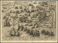
The cartouche text translates as follows: Conil, an important Spanish town on the Strait of Hercules; well known due to its lucrative tuna fishing.
Conil de la Frontera
The translation of the verso text is as follows:
Conil, an attractive little town in Spain, well known due to its abundance of fish, especially tuna, which is caught there in large quantities. This town seems to have been destined by nature for fishing. [...] It has a baronial castle and next to it a very big house called La chauca de Ducque, where the fish are cut into pieces, salted and then exported in unbelievable quantities to Italy and the whole of the Mediterranean region with big ships."
The view of the small Atlantic port Conil de la Frontera is pushed into the background by the depiction of fishermen at work. On the bank of the river fishermen are bringing in their nets, and in the foreground fish are being dried and cut up. The mountain of salt on the left is used to cure the fish, which is then stored in wooden barrels. After Alfonso X succeeded in recapturing Conil from the Moors in 1265, the fishing monopoly was granted to the nobleman Alonso Pérez de Guzman in 1295. Tuna fishing continued to be the town's most important source of income for a long time. This southern Spanish town in the province of Cadiz in Andalusia lies on the popular Costa de la Luz, and is one of the much frequented pueblos blancos, or white villages.
Jerez De La Frontera
The translation of the verso text is as follows:
Jerez is a famous and splendid city in Andalusia. [...] From here a strong and delectable wine is exported to Germany, Italy, England, Scotland, the Orient, even as far as India and other countries of the world. [...] This is where the very best and fastest horses in the whole of Spain, which are called Genets, can be found. The nobles know how to train them expertly."
The engraving shows the Andalusian city of Jerez de la Frontera in the background. The strongly fortified city walls indicate the role that Jerez played as a frontier town between the Moorish and Christian areas of sovereignty. After its recapture in 1264 by Alfonso X, King of the Romans, the church of San Salvador was built on the site of the old mosque, and it can be seen in the engraving to the right of the centre. Jerez attained world fame mainly through the production of sherry, the name being derived from the pronunciation of the town's earlier Arabic name, "Sherish". After the final defeat of the Moors in 1492, horse breeding flourished. Today the city of Jerez is still well known for its "vino Jerez" (sherry), and because of the Royal Andalusian School of Equestrian Art.
Civitates Orbis Terrarum: The Greatest City Book
Georg Braun and Frans Hogenberg began the process of creating a comprehensive atlas of the cities of the world in 1572. Their book, Civitates Orbis Terrarum, was originally intended as a companion to Abraham Ortelius's Theatrum Orbis Terrarum, the first true atlas.
The great atlas was edited by Georg Braun, with Franz Hogenberg engraving many of the views. When the project was finished, the series would contain over 546 views (sometimes with multiple views on a single plate).
Civitates Orbis Terrarum includes the work of over 100 artists and topographers, perhaps most notable among them was the superlative talent of Joris Hoefnagel (1542-1600). He provided original drawings of Spanish and Italian towns, as well as reworking and improving the town drawings of other artists. After Joris's death, his son Jakob continued the project.
The Civitates provides an incredibly comprehensive view of urban life in the late 16th century. Many of the views in these volumes are the earliest of their respective towns -- either absolutely, or they are predated only by impossible rarities, as in the case of London. Cities portrayed range from the great capitals of Europe, Asia, Africa, and the Americas to small Swiss hamlets and other tiny villages. As such, this singular and indispensable source for understanding the early modern world.
The work was published in six volumes, each of which contained approximately sixty plates. The subject matter of each plate varied widely, it could provide a single view of a city, two views of the same city, or views of up to nine different cities. The range of designs is extensive, and it is interesting to compare the variety between views of the same city by two different authors.
Georg Braun (1541-1622) was born and died in Cologne. His primary vocation was as Catholic cleric; he spent thirty-seven years as canon and dean at the church St. Maria ad Gradus, in Cologne. Braun was the chief editor of the Civitates orbis terrarum, the greatest book of town views ever published. His job entailed hiring artists, acquiring source material for the maps and views, and writing the text. In this role, he was assisted by Abraham Ortelius. Braun lived into his 80s, and he was the only member of the original team to witness the publication of the sixth volume in 1617.
Frans Hogenberg (ca. 1540-ca. 1590) was a Flemish and German engraver and mapmaker who also painted. He was born in Mechelen, south of Antwerp, the son of wood engraver and etcher Nicolas Hogenberg. Together with his father, brother (Remigius), uncle, and cousins, Frans was one member of a prominent artistic family in the Netherlands.
During the 1550s, Frans worked in Antwerp with the famous mapmaker Abraham Ortelius. There, he engraved the maps for Ortelius’ groundbreaking first atlas, published in Antwerp in 1570, along with Johannes van Deotecum and Ambrosius and Ferdinand Arsenius. It is suspected he engraved the title page as well. Later, Ortelius supported Hogenberg with information for a different project, the Civitates orbis terrarium (edited by Georg Braun, engraved by Hogenberg, published in six volumes, Cologne, 1572-1617). Hogenberg engraved the majority of the work’s 546 prospects and views.
It is possible that Frans spent some time in England while fleeing from religious persecution, but he was living and working in Cologne by 1580. That is the city where he died around 1590. In addition to his maps, he is known for his historical allegories and portraits. His brother, Remigius, also went on to some fame as an engraver, and he died around the same time as his brother.
![(Spanish Riviera) Plan de la Rade de la Carbouiere avec les Quartiers. . . [Plan of the Road of Carbouiere with the Quarters. . .]](https://storage.googleapis.com/raremaps/img/small/94405.jpg)