|
||

|

|
|

|
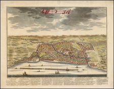
Decorative view of Ternate in the Bacan islands (eastern Indonesia). The map is attractively laid out, with a large central volcano spewing smoke that occupies the center of the view. Numerous tall ships sail around the foreground, and a long pier juts out into the Sea of Molucca. A large community (the Portuguese Fortress Oranje) is at the center of the town, and pine trees climb up the sides of the volcano. An index at the bottom of the map denotes six places of interest.
Located in the center of the Maritime Continent, Ternate lies off the coast of North Maluku. Dominated by a single extremely active stratovolcano, Mount Gamala, several significant ash and mudflow events have happened in the last decade. The last major eruption was in 1775.
In the upper-left is an inset of a fort titled "de Fortres Gamma-Lamma".
This view first appeared in Valetijn's Oud en Nieuw Oost-Indien. . ., which was a five-part, eight-volume masterpiece which informed European readers about Southeast Asia and was based on Valentijn's trips to the East Indies for the V.O.C. (Dutch East India Company).
Valentijn was born in 1666 in Dordrecht, Holland, but spent significant time in the tropics, notably in Ambon, in the Maluku Archipelago. In total, Valentijn lived in the East Indies 16 years. Valentijn was first employed by the Dutch V.O.C. or East India Company (Vereenigde Oost-Indische Compagnie), at the age of 19, where he served as Minister to the East Indies. He returned to Holland for about ten years, before returning to the Indies in 1705, where he was to serve as Army Chaplain on an expedition in eastern Java. He again returned to Dordrecht where he wrote his Oud en Nieuw Oost-Indien (1724-26), a massive work of five parts published in eight volumes and containing over one thousand illustrations and including some of the most accurate maps of the Indies of the time. He died in The Hague, Netherlands, in 1727.
Valentijn likely had access to the V.O.C.'s archive of maps and geographic secrets which they had always guarded jealously. Johannes Van Keulen II became Hydrographer to the V.O.C. in the same year Valentijn's book was published. It was in Van Keulens time that many of the VOC charts were published, one signal of the decline of Dutch dominance in Spice Trade. Valentijn was fortunate to have seen his work published, as the VOC (Dutch East India Company) strictly enforced a policy prohibiting former employees from publishing anything about the region or their colonial administration. And while, as Suárez notes, by the mid-18th Century the Dutch no longer feared sharing geographic secrets, the execution of this policy was still erratic and based on personal motives.
While Valentijn's maps and diagrams were prized possessions, his scholarship, judging by contemporary standards, was not of the highest integrity. While current standards of referencing and plagiarism were not in effect during the 18th Century, Valentijn's borrowed liberally from other scientists' and writers. E.M Beekman referred to Valentijn as an "exasperating Dutch braggart," but nevertheless cites him as an important figure and given his writing style, diction and penchant for story, one of the greatest Dutch prose writers of the time-going so far as to suggest comparison between one of the various stories in his work and a Chaucerian tale.
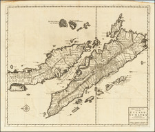
![[Moluccas] Caart van het Eyland Manipa [on sheet with] Caart van het Eyland Noessa-Laoet [and] Caart van het Eyland Honimoa [and] Caart van het Eyland Oma](https://storage.googleapis.com/raremaps/img/small/74805.jpg)