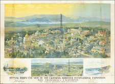
|
||

|

|
|

|
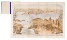
Great antique map of San Jose, California, published after the turn of the century. The map shows the central core of modern San Jose, as well as including suburbs such as Rose Garden, Horace Mann, the city's Japantown, Julian-St. James, Naglee Park, and Willow Glen.
An index to public buildings is provided, listing 36 important centers including nine schools, nineteen places of worship (eighteen churches and one synagogue), and several city buildings. A series of concentric circles showing the distance from the center of town (at Santa Clara and 1st street) at eighth of mile contours are shown. In the northeast of the map, the old campus of the University of the Pacific, in College Park, can be found. The railroad lines, including the S.P.R.R. are shown.
A manuscript "x" is placed at the corner of 9th Street and William Street, now two blocks away from San Jose State University.
In 1909 San Jose was only just recovering from the devastating 1906 earthquake. While not as completely destroyed as the downtown San Francisco area, many San Jose buildings were damaged, including the old City Hall near present-day Cesar Chavez park. The main industry of this now technology-driven center, at the time of this map's creation, was agriculture.
Rarity
OCLC only lists one example of this map, in the San Jose Public Library. This map only has one record of being on the market, in 2013, this is likely that example. We were unable to trace any additional examples of this map.
![[ Downtown St. Helena ] Mattioli's in your Pocket Guide St. Helena -- 13th Annual Edition [ Napa Valley, CA ]](https://storage.googleapis.com/raremaps/img/small/102768.jpg)