|
||

|

|
|

|
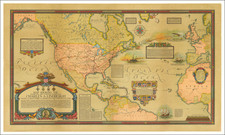
An exceptional example of Colton's map of the route to the Gold Regions, perhaps the most famous and sought after of all gold rush overland guides. The map shows the routes from Independence, Missouri to the Gold Regions, including the Oregon Route, Central Route and a Southern Route that follows Kearny's Route through San Diego, then proceeds by Steamship up the coast to San Francisco. An overland route from Refugio, Texas on the Gulf Coast is also noted, again extending to San Diego and then via Steamship to San Francisco. There are also two overland routes noted in Central America. Includes a large inset map of the Gold Regions. Notably, there is an indication of Gold in the Los Angeles area. The present example of the map has been removed from the folder, flattened and laid down on linen, although the original folder and text are present. The result is a nearly flawless unfolded example, the best we have seen in the past 14 years. Colton's map gained prominence among overland traveller's to the gold regions and is frequently mentioned in contemporary accounts. The map has become a tremendous rarity on the market in recent years, this being the first example we have seen in the past 5 years on the market. An essential map for collectors of the region. The text is also of note. Extremely rare, especially with original pastedown label on the covers. Graff 835; Kurutz; The California Gold Rush 149; Wheat, Transmississippi West 591; Gold Regions 70.
G. W. & C. B. Colton was a prominent family firm of mapmakers who were leaders in the American map trade in the nineteenth century. Its founder, Joseph Hutchins Colton (1800-1893), was a Massachusetts native. Colton did not start in the map trade; rather, he worked in a general store from 1816 to 1829 and then as a night clerk at the United States Post Office in Hartford, Connecticut. By 1830, he was in New York City, where he set up his publishing business a year later.
The first printed item with his imprint is dated 1833, a reprint of S. Stiles & Company’s edition of David Burr’s map of the state of New York. He also printed John Disturnell’s map of New York City in 1833. Colton’s next cartographic venture was in 1835, when he acquired the rights to John Farmer’s seminal maps of Michigan and Wisconsin. Another early and important Colton work is his Topographical Map of the City and County of New York and the Adjacent Country (1836). In 1839, Colton began issuing the Western Tourist and Emigrant’s Guide, which was originally issued by J. Calvin Smith.
During this first decade, Colton did not have a resident map engraver; he relied upon copyrights purchased from other map makers, most often S. Stiles & Company, and later Stiles, Sherman & Smith. Smith was a charter member of the American Geographical and Statistical Society, as was John Disturnell. This connection would bear fruit for Colton during the early period in his career, helping him to acquire the rights to several important maps. By 1850, the Colton firm was one of the primary publishers of guidebooks and immigrant and railroad maps, known for the high-quality steel plate engravings with decorative borders and hand watercolors.
In 1846, Colton published Colton’s Map of the United States of America, British Possessions . . . his first venture into the wall map business. This work would be issued until 1884 and was the first of several successful wall maps issued by the firm, including collaborative works with D.G. Johnson. From the 1840s to 1855, the firm focused on the production of railroad maps. Later, it published a number of Civil War maps.
In 1855, Colton finally issued his first atlas, Colton’s Atlas of the World, issued in two volumes in 1855 and 1856. In 1857 the work was reduced to a single volume under the title of Colton’s General Atlas, which was published in largely the same format until 1888. It is in this work that George Woolworth (G. W.) Colton’s name appears for the first time.
Born in 1827 and lacking formal training as a mapmaker, G. W. joined his father’s business and would later help it to thrive. His brother Charles B. (C. B.) Colton would also join the firm. Beginning in 1859, the General Atlas gives credit to Johnson & Browning, a credit which disappears after 1860, when Johnson & Browning launched their own atlas venture, Johnson’s New Illustrated (Steel Plate) Family Atlas, which bears Colton’s name as the publisher in the 1860 and 1861 editions.
J.H. Colton also published a number of smaller atlases and school geographies, including his Atlas of America (1854-56), his Illustrated Cabinet Atlas (1859), Colton’s Condensed Cabinet Atlas of Descriptive Geography (1864) and Colton’s Quarto Atlas of the World (1865). From 1850 to the early 1890s, the firm also published several school atlases and pocket maps. The firm continued until the late 1890s, when it merged with a competitor and then ceased to trade under the name Colton.
![[ United States ] Etats-Unis de l'Amerique](https://storage.googleapis.com/raremaps/img/small/98821.jpg)
![[Limited Edition of 33] The Sculpture & Art of Jo Mora](https://storage.googleapis.com/raremaps/img/small/94900.jpg)
![[Appointment of Ben E.S. Ely as Notary Public for Napa County, California - September 26, 1861]](https://storage.googleapis.com/raremaps/img/small/93309.jpg)