|
||

|

|
|

|
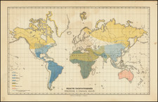
A Rare Ethnographic Pictorial Game Board Map
Rare educational game map of the world, published in Stuttgart by Carl Ebner.
The map apparently shows the geography of the world explorations up to the time of Captain James Cook at the end of the 18th Century, including an ethnographic depiction of an early Hawaiian.
The game comprises a tour of the globe, with players moving through 60 ethnographic regions represented by costumed peoples, with a key identifying each region. The game instructions are shown below the map with a key to each of the sixty stopping points.
Ebner was a printer in Stuttgart. There are apparently several versions of the map. We note for example a different example, published in Nuremberg in about 1820, by Friedrich Campe.
While the auction house which previously handled this map in 2007 suggested a date of 1790-1800, it seems clear that Carl Ebner was active in the 1820s and 1830s and that this map is likely an early work, contemporary to the similar map by Friedrich Campe, hence a more likely date circa 1820.
Rarity
The map is very rare on the market. We note an example at auction in 2007 and an example of the later Friedrich Campe in a dealer catalog in 2005.
We were not able to locate an example of this map in OCLC and only a single example of the Friedrich Campe edition (National Library of Australia).
![[Grotto of Tethys -- Versailles] Le Soleil qui se couche dans la mer / Le Globe de la Terre, divise en six parties.](https://storage.googleapis.com/raremaps/img/small/79606.jpg)