


|
||

|

|
|

|
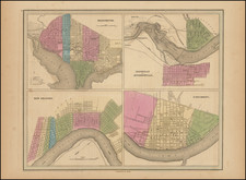
Four early city maps from the first edition of Bradford's Atlas. The maps show Washington, D. C., New Orleans, Jeffersonville, and Cincinnati.
Each of these maps shows streets and blocks and is colored by neighborhood. Important streets and buildings are named. Relief is indicated.
Thomas Gamaliel Bradford (1802-1887) was an American geographic publisher. He hailed from Bradford, Massachusetts and began his publishing career by working for the America Encyclopedia. Then, he edited and republished the Atlas Designed to Illustrate the Abridgement of Universal Geography, Modern & Ancient, which had originally been offered in French by Adrian Balbi. In 1835, he published another atlas, A Comprehensive Atlas: Geographical, Historical & Commercial, and, in 1838, An Illustrated Atlas Geographical, Statistical and Historical of the United States and Adjacent Countries. His interests were primarily in educational publishing and he was one of the first mapmakers to show Texas as an independent country.
![[Eastern Sheet -- Ohio] Post Road Map of the States of Ohio and Indiana with Adjacent Parts of Pennsylvania Michigan Illinois Kentucky and West Virginia Showing Post Offices With The Intermediate Distances and Mail Routes In Operation On the !st of February 1885 . . .](https://storage.googleapis.com/raremaps/img/small/44153.jpg)

![Maryland & Delaware and the District of Columbia [large Washington inset]](https://storage.googleapis.com/raremaps/img/small/100301.jpg)
![[ Ohio - Seven Ranges ] Plat of the Seven Ranges of Townships being Part of the Territory of the United States N.W. of the River Ohio which by a late act of Congress are directed to be sold . . . 1785](https://storage.googleapis.com/raremaps/img/small/82394.jpg)