|
||

|

|
|

|
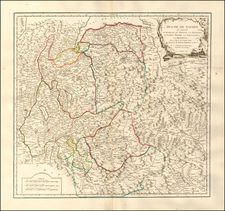
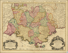
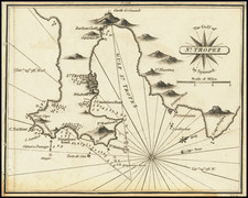
Decorative early regional map of Provence, with an elaborate cartouche and attractive hand-coloring. This map, by the important French cartographer Nicolas Sanson, shows the French Mediterranean coast from the mouth of the Rhone River to the Italian border. The map includes a scale bar as well as latitude and longitude bearings.
Detail on this map is extensive, with many forests, towns, rivers, marshes, and more all shown on land. Numerous important and desired French cities and towns are named, including, Marseille, Arles, the Cap de Benat, St. Tropez, Cannes, Nice, Monaco (also named Mourgues), and Aix-en-Provence. Provence is well known around the world for its coastal beaches, attractive seaside towns, and lavender fields.
Sanson's maps are renowned for their accuracy and the number of features they show, and they are some of the earliest regional maps of France to be published in France with such high quality.
Nicholas Sanson (1600-1667) is considered the father of French cartography in its golden age from the mid-seventeenth century to the mid-eighteenth. Over the course of his career he produced over 300 maps; they are known for their clean style and extensive research. Sanson was largely responsible for beginning the shift of cartographic production and excellence from Amsterdam to Paris in the later-seventeenth century.
Sanson was born in Abbeville in Picardy. He made his first map at age twenty, a wall map of ancient Gaul. Upon moving to Paris, he gained the attention of Cardinal Richelieu, who made an introduction of Sanson to King Louis XIII. This led to Sanson's tutoring of the king and the granting of the title ingenieur-geographe du roi.
His success can be chalked up to his geographic and research skills, but also to his partnership with Pierre Mariette. Early in his career, Sanson worked primarily with the publisher Melchior Tavernier. Mariette purchased Tavernier’s business in 1644. Sanson worked with Mariette until 1657, when the latter died. Mariette’s son, also Pierre, helped to publish the Cartes générales de toutes les parties du monde (1658), Sanson' atlas and the first French world atlas.