The item illustrated and described below is sold, but we
have another example in stock. To view the example which
is currently being offered for sale, click the
"View Details" button below.


|
||

|

|
|

|
Stock# 76055
Description
With English and Portuguese-Language Manuscript Annotations
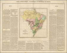
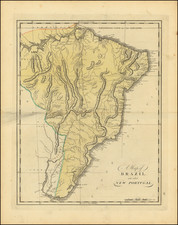
Interesting map of Brazil from the 1814 edition of Matthew Carey's General Atlas. The map shows the territory of Brazil from the mouth of the Amazon to the Rio de la Plata.
In this detailed and well-executed American-published map, the many rivers, mountain ranges, cities, and islands of Brazil are all shown. Detail extends several hundred miles inland, but the westernmost part of the map is left blank and labeled "Peru."
Fascinating English and Portuguese language annotations appear in the upper portion of the map as well as near the title. These detail the demographics, education system, culture, and more of Brazil.
Condition Description
Original hand-color. Extensive, fairly early, manuscript annotations at the top in pencil.
![[ Brazil ] Brasilia Lusitanorum in XIV praefecturas divis. Per N. Sanson](https://storage.googleapis.com/raremaps/img/small/97912.jpg)