|
||

|

|
|

|
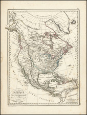
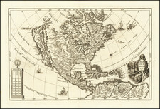
Rare edition of Jaillot's map of North America, published at the conclusion of American Revolution but prior to the Treaty of Peace in 1783.
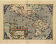
Jaillot originally published a 2 sheet map of North America in 1674, which was thereafter issued for the next 50 years, with revisions, and later copied by Mortier. This first map was based upon the earlier maps of Nicholas Sanson, with California shown as an island and a set of open Great Lakes. In 1695, Jaillot published a new single sheet plate for his L'Atlas Francois. Burden notes that by this time, Jaillot's relationship with the Sanson heirs was strained and many of the maps in this production were from new or original sources. Several minor date changes were made to the plate in 1698 and 1700.
Perhaps the easiest way to quickly distinguish this 1695 (and later) editions of Jaillot's map, is by the inclusion of the two parrots at each side of the title cartouche, which was engraved by the noted cartouche engraver C. Simoneau. The map also includes a unique dedication to the King, which differs from the other Jaillot and Morter maps.
In 1713, a 4th state of the map was engraved, in which the map was extensively revised, bringing it in line with the contemporary cartography of Guillaume De L'Isle and Nicholas De Fer. The depiction of the Great Lakes was updated to conform to De L'Isle's map of 1700 and the course of the Mississippi (erroneously based upon La Salle's report, which placed the mouth of the Mississippi in Texas, several hundred miles west of its true terminus) and Ohio Rivers were included for the first time on a Jaillot map, again following Jaillot's model. Additional information was included in the Southwestern US, most notably the addition of the Rio De Las Vacas, in Texas. The Rio Grande is now properly shown flowing into the Gulf of Mexico. The British Colonies in North America are now shown.
In 1719, Jaillot added two significant updates. First, California was re-attached to the mainland, ending its 45 year run as an island on Jaillot's maps. In addition, Jaillot for the first time revises the east coast of North America, including the French claim to Caroline (the Carolinas), Mariland, Pensilvanie and Nouv.York. The reference to Terra Iesso has also been removed.
After Bernard-Jean-Hyacinth Jaillot's death in 1739, his daughters conducted the business until 1757. The business was then taken over by Jean Baptiste Michele Renou de Chauvigne, who ran the business until about 1780. In 1780, following his death, the plates were sold to Jean Claude Dezauche and Louis Charles Desnos, who revised the map and issued a 6th State in 1781 and then a final, highly revised state in 1783.