|
||

|

|
|

|
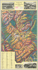
A Monumental Map of the Crow Agency
This large map of the Crow Reservation identifies the names of about 2,300 members of the Crow Agency who owned land on the reservation in 1907. Names are keyed to Township, Range, Section, and Sub-Section numbers.
The map is perhaps the only surviving comprehensive snapshot of land ownership in the Crow Agency in this period.
Allotment Lands
The U.S. federal government began the policy of allotting Indian land as early as 1798. Several treaties with Indian tribes included provisions that stated land would be divided among their individual members. After 1871, however, Congress declared that no further treaties would be made and all future dealings with Indians would be conducted through legislation.
The Allotment advocates eventually succeeded in convincing the federal government to adopt the policy nationally. In 1887, Congress passed the General Allotment Act, which authorized the president to survey Indian tribal land and divide the area into allotments for individual Indians and families. The Allotment Act (also known as the Dawes Act, named for Senator Henry Dawes of Massachusetts) was applied to reservations whenever, in the president’s opinion, it was advantageous for particular Indian nations. Members of the selected tribe or reservation were either given permission to select pieces of land – usually around 40 to 160 acres in size – for themselves and their children, or the tracts were assigned by the agency superintendent. If the amount of reservation land exceeded the amount needed for allotment, the federal government could negotiate to purchase the land from the tribes and sell it to non-Indian settlers. As a result, 60 million acres were either ceded outright or sold to the government for non-Indian homesteaders and corporations as “surplus lands.”
Although the General Allotment Act was the first major piece of legislation designed to allot Indian reservations across the U.S., many tribes were allotted under special legislation that was unique to their tribe or reservation.
John Knox Rankin and Carl Rankin
Colonel John Knox Rankin (1837-1913) was a Civil War Veteran, with a career in public service, including serving as a Kansas State Senator. In 1890, he was appointed “special allotting and disbursing agent in the Indian Service,” and performed that duty for nineteen years, making allotments to about 15,000 Indians in Washington, Arizona, New Mexico, Montana, Oklahoma and Nebraska.
Beginning around 1904, Colonel Rankin apparently employed his son Carl Rankin as a surveyor. In June 1906, Carl Rankin was also advertising his services as "Locating Engineer for Crow Reserve Opening" (Billings Gazette, June 21, 1906).
Carl Rankin was also actively involved in real estate speculation and development with the Lincoln Townsite Company, the development arm of the Chicago, Burlington and Quincy Railroad, which would acquire and promote several townsites in the Crow Agency on lands acquired through Allotment sales. The Company purchased Crow Reservation allotments and platted several townsites, including the town of Hardin, Fort Custer. Carl Rankin would later serve as two term mayor of Hardin.
This matter became the subject of a US Senate inquiry in 1908, charging that the Rankins had an inappropriate financial interest in several townsites developed by the Company. Carl Rankin was then serving as both a surveyor for his father and Agent of the Lincoln Townsite Company at the same time (per advertisement in the Billings Gazette). These advertisements were run as early as May 1907.
By 1910, Carl Rankin had left the area and there were newspaper published accounts of other fraud and improprieties associated with the developments, which were described in one article the Butter Miner of November 5, 1910 as "True Story of Senator [Thomas H.] Carter and the Crow Agency Ring," which tells a story of multiple frauds perpetrated on both native American Allotment claimants and subsequent other schemes involving farm land and water supplies around the Hardin townsite.
Rarity
We note only the example at the Library of Congress.