


|
||

|

|
|

|
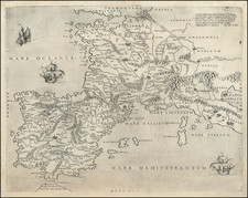
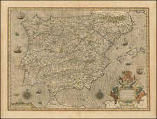
Impressive Lafreri School Map of France and the Iberian Peninsula
This is a spectacular Italian-published map of western Europe from 1554. It displays classic hallmarks of the Lafreri School style of engraving, most notable in its hydrographic and topographic representations; this work is attributed to Antonio Lafreri himself.
The detail on the map starts at the Rhine River and encompasses all of France and Spain, as well as some of Italy. Important cities and towns are named throughout, with larger cities depicted pictorially. Additional pictorial elements are included: three ships are shown in the ocean, and the Towers of Hercules loom over the Mediterranean.
The title describes the map as:
The true description of all France, Spain, and Flanders, showing the Cities, Oceans, Rivers, and Ports in each. The other parts which surround them are only placed so as to locate these areas. Each item on the map was diligently made and measured.
This map is an updated version of the map engraved by Enea Vico and published in Rome in 1542. Most prior research, including Bifolco and Ronca, attributes the map to Antonio Lafreri. This is supported by its appearance in the c. 1574 Lafreri catalog, wherein it is listed as "Una Parte d'Europpa" [A Part of Europe].
No later states or updated editions of this map are known to exist.
Rarity
According to RBH and OldMaps.com, the map has not appeared on the market in over a decade. An example at sold at Christie's in 2006 for €2,040.
The Lafreri School is a commonly used name for a group of mapmakers, engravers, and publishers who worked in Rome and Venice from ca. 1544 to 1585. The makers, who were loosely connected via business partnerships and collaborations, created maps that were then bound into composite atlases; the maps would be chosen based on the buyer or compiler’s interests. As the maps were initially published as separate-sheets, the style and size of maps included under the umbrella of the “School” differed widely. These differences can also be seen in the surviving Lafreri atlases, which have maps bound in with varying formats including as folded maps, maps with wide, trimmed, or added margins, smaller maps, etc.
The most famous mapmakers of the School included Giacomo Gastaldi and Paolo Forlani, among others. The School’s namesake, Antonio Lafreri, was a map and printseller. His 1572 catalog of his stock, entitled Indice Delle Tavole Moderne Di Geografia Della Maggior Parte Del Mondo, has a similar title to many of the composite atlases and thus his name became associated with the entire output of the larger group.
Antonio Lafreri (1512-1577) (also known as Antoine Lafréry and Antoine du Pérac Lafréry) was a French mapmaker, engraver, and publisher who worked in Italy. Lafreri was born in Franche-Comté and moved to Rome around 1540. Lafreri sold sheet maps but he also bound maps into books for his clients based on their interests and needs. These are the famous Lafreri atlases, important pre-cursors to the modern atlas. He also published well known works such as the Speculum Romanae Magnificentiae (ca. 1575), a collection of engraved views and images of Rome. Lafreri was well-connected to the cartographic networks of the time, collaborating with Giacomo Gastaldi, Battista Agnese, Antonio Salamanca, Donato Bertelli, Paolo Forlani, and others.
![[ Straits of Gibraltar ] Le Detroit de Gibraltar ou sont Exactement Observee La Maree](https://storage.googleapis.com/raremaps/img/small/97818.jpg)
![[Grenoble 1968 Winter Olympics] L'Alpe D'Huez France - Isere](https://storage.googleapis.com/raremaps/img/small/84340.jpg)