


|
||

|

|
|

|
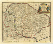
The Most Exact Contemporary Copy of Perhaps The Most Important Early Map of Hungary, All Examples of Which are Thought to be Destroyed
Rare 1578 first edition of the de Jode family's map of Hungary, showing the flow of the Danube and a great deal of place names, geographical features, and other points of interest. The map includes the coats of arms of Hungary, being born by two cherubs.
This map was based on the 1552-53 partial map of Hungary produced by Augustin Hirschvogel, which was left uncompleted due to his untimely death. The map was to serve as an updated version of the roughly-outlined earlier Lazarus map. This map is at present unknown--the last traced was destroyed at the Breslau Library during the Second World War. Photo-facsimiles of the map reveal that this original map is a woodcut printed on twelve sheets, forming a huge map. This map was drawn on and copied by Ortelius and de Jode for their respective atlases.
Comparison of the Ortelius and de Jode maps shows that Ortelius reduces the region shown, while de Jode utilizes the full area depicted in Hirschvogel's edition. Ortelius omits the regions of Bacska, Banat, Sirmivir, and Serbia. Both later editions also orient the map to the north, as opposed to Hirschvogel's southwards orientation. De Jode also includes more of the toponyms which are visible but unreadable on the photo facsimile of Hirschvogel's map. As such, this contemporary copy is of great importance to Hungarian collectors as the best-surviving reproduction of Hirschvogel's map.
De Jode's Speculum Orbis Terrarum
One of the great rarities of sixteenth-century mapmaking, the De Jode family's Speculum Orbis Terrarum represents over twenty-five years of work shared between two generations. The work was published in two editions, first by Gerard de Jode in 1578 and then in an expanded edition by his son, Cornelis, in 1593.
The Speculum is the second general atlas of the world, after Ortelius' Theatrum Orbis Terrarum. In Antwerp, in 1570, Ortelius published the first modern atlas; that is, a set of uniform maps with supporting text gathered in book form. Previously, there were other bound map collections, specifically, the Italian Lafreri atlases, but these were sets of maps—not necessarily uniform—selected and bound together on demand.
The first edition of Gerard De Jode’s atlas was published in Antwerp in 1578. Gerard De Jode (1509-1591) released his atlas in a golden age of Dutch atlas production: Ortelius’ atlas was released in 1570, also in Antwerp; the first town atlas was in 1572, the first pocket atlas in 1577, the first regional atlas in 1579, the first nautical atlas in 1584, and the first historical atlas in 1595. De Jode’s atlas was intended as competition for Ortelius’. Mercator was also preparing an atlas at the time, and corresponded with Ortelius, but it would not appear in full until 1595, a year after Mercator’s death.
Although the Speculum was ready as early as 1573, it was not published until 1578. This is most likely due to Ortelius’ influence and his privilege over atlas production, which expired just before De Jode finally published. The atlas was the result of collaboration between De Jode, the geographer Jan van Schille of Antwerp, German physician Daniel Cellarius, and the etchers Joannes and Lucas van Doetecum.
Although never as successful as Ortelius’ Theatrum, the Speculum did get republished in a second edition in 1593, two years after De Jode’s death, by Arnold Coninx. After his death, Gerard’s son, Cornelis (1568-1600), and his wife, Paschina, then ran the shop. Unfortunately, Cornelis died young in 1600, aged only 32, and the stock and plates were sold to the publisher Joan Baptista Vrients. Vrients had also recently purchased the plates for Theatrum, giving him a monopoly over Antwerp atlas publication. Vrients acquired the De Jode atlas plates only to suppress them in favor of the Ortelius plates, thus the De Jode atlas maps are quite rare on the market today.
Scholarly and historical comparison between the Speculum and the Theatrum varies. The great cartographers of the late sixteenth- and early seveneenth-centuries, including Montanus, van den Keere, and von Aitzing, used both as sources, and Hondius compared the former work favorably against the latter. Later scholarly review notes less consistency in the cartography in de Jode's work, particularly in some of the Germanic regions, although the craftsmanship of the engraving is highly praised.
Gerard De Jode (1509-1591) was a pre-eminent mapmaker in the late seventeenth century, a time when the Dutch dominated the map trade. He was known for his many maps, some of which featured in Speculum Orbis Terrae (first edition Antwerp: 1578). Although never as successful as Ortelius’ Theatrum, the Speculum did get republished in a second edition in 1593, two years after De Jode’s death, by Arnold Coninx, and included this map. After his death, Gerard’s son, Cornelis (1568-1600), and his wife, Paschina, ran the shop. Unfortunately, Cornelis died young in 1600, aged only 32, and the stock and plates were sold to the publisher Joan Baptista Vrients.
![(Second World War II - Air Navigation) Vogels Karte von Mitteleuropa [Vogel's Map of Central Europe]](https://storage.googleapis.com/raremaps/img/small/89945.jpg)
![[Poland, Croatia, Slovenia, Hungary, Serbia, Romania, Ukraine, Bulgaria] (La discrittione della Transylvania et parte del l'Ungaria, et il simil della Romania)](https://storage.googleapis.com/raremaps/img/small/59225.jpg)
![[ Central Hungary]](https://storage.googleapis.com/raremaps/img/small/103268.jpg)