|
||

|

|
|

|
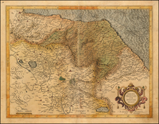
Fantastic map of the Istrian Peninsula, showing the border between Italy, Serbia, and Croatia. The depicts the peninsula in great detail as seen from the southwest and contains marvelous Lafreri School stylistic tendencies.
The map is derived from the 1525 Pietro Coppo map of the region, as suggested in the dedication. This explains the variation in accuracy as one moves eastwards across the peninsula. The western two-thirds were under Venetian control at the time of Coppo's survey, however, the eastern third was under Hapsburg control and thus Coppo was unable to survey here. The Coppo map is known in only one example.
This map shows fantastic detail, with a stippled sea and two sailing ships. Bifolco and Ronca suggest that the map is almost Gothic in style, with the particularly imposing mountains seen in the northern part of the map contrasting with the more typical undulating hills of normal Lafreri style.
This map appears in the Lafreri catalog, and it is likely that he had the right to distribute the map in Rome. In all, a very nice map of the region.
The Lafreri School is a commonly used name for a group of mapmakers, engravers, and publishers who worked in Rome and Venice from ca. 1544 to 1585. The makers, who were loosely connected via business partnerships and collaborations, created maps that were then bound into composite atlases; the maps would be chosen based on the buyer or compiler’s interests. As the maps were initially published as separate-sheets, the style and size of maps included under the umbrella of the “School” differed widely. These differences can also be seen in the surviving Lafreri atlases, which have maps bound in with varying formats including as folded maps, maps with wide, trimmed, or added margins, smaller maps, etc.
The most famous mapmakers of the School included Giacomo Gastaldi and Paolo Forlani, among others. The School’s namesake, Antonio Lafreri, was a map and printseller. His 1572 catalog of his stock, entitled Indice Delle Tavole Moderne Di Geografia Della Maggior Parte Del Mondo, has a similar title to many of the composite atlases and thus his name became associated with the entire output of the larger group.
![[ Istria / Croatia / Slovenia / Fruili ] Forum Iulium Karstia, Carniola Histria et Windorum Marchia](https://storage.googleapis.com/raremaps/img/small/61612.jpg)
![[ Danube River ] Danubii Fluminis . . . Pars Media in qua Hungaria, Sclavonia, Bosnia, Dalmatia et Servia . . . . [and] Danubii Pars Infima in qua Transylvania, Walachia, Bulgaria, Servia, Romania, et Bessarabia . . .](https://storage.googleapis.com/raremaps/img/small/104042.jpg)