


|
||

|

|
|

|
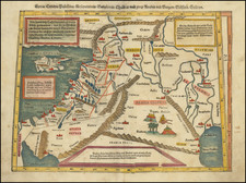
Rare 16th Century Van Deutecum Map of the Holy Land
Fine early map of the Holy Land, engraved by Johannes van Deutecum the Younger.
This is one of a series of six maps of the Holy Land engraved by Deutecum family for bibles issued beginning in the 1590s. This series of maps would become the model for maps which appeared in Dutch, German and other bibles published in the 17th and 18th Centuries. Arguably, this set of maps was the most influential set of Holy Land maps ever published, when one considers the scope of the audience and duration of their legacy.
The map is oriented with east at the top and shows the land of Canaan, divided among the regions of Galilee, Samaria, and Judea. At the top is the region of the 'Ammonites' and the 'Moabiter Landt'. The Mediterranean includes an elaborate compass rose, 2 sailing ships and a sea creature.
At the bottom right is an image of Christ entering Jerusalem on a donkey. In the Sea of Galilee, Peter is walking on water. The cities of Sodom and Gomorra appear to be on fire in the Dead Sea, along with Zeboim and Adama.
Rarity
The map is very rare on the market. We were unable to locate a separate example of the map in either AMPR or RBH.
![(Israel) Tabula Moderna Terre Sancte [Modern Map of the Holy Land]](https://storage.googleapis.com/raremaps/img/small/101884.jpg)
![[Solomon's Kingdom] Regnum Salomonicum Seu Tabula digesta ad Libros Iudicum Regum, Paral. et Prophet Per Eparchias XII, Mox Regna duo Auctore Phil. de la Rue . . .](https://storage.googleapis.com/raremaps/img/small/92371.jpg)